南海海底地震仪异常数据的分析和处理
1. 中国科学院边缘海地质重点实验室, 中国科学院南海海洋研究所, 广州 510301;
2. 中海石油(中国)有限公司深圳分公司, 广州 510240;
3. 中国科学院大学, 北京 100049
2. 中海石油(中国)有限公司深圳分公司, 广州 510240;
3. 中国科学院大学, 北京 100049
摘要: 海底地震仪(Ocean Bottom Seismometer, OBS)数据处理至关重要,是获取深部地壳结构的基础与前提.2006年实施OBS2006-2测线时,有2台OBS(OBS03,OBS06)数据出现异常,无法使用.由于海上航次花费巨大,采集到的数据弥足珍贵.本文采用数据格式检查、邻近台站对比分析、重采样等方法,成功地对这2台OBS数据进行了解编处理,得到了这两个台站的综合地震记录剖面;利用上述方法对2011年实施的OBS973-3测线中的异常台站OBS03进行了分析处理,同样得到了OBS03台站的综合地震剖面;通过查看两次海上实验班报发现,OBS2006-2测线之OBS06与OBS973-3测线之OBS03内部Sedis编号相同,为同一台记录仪器,再一次验证上述处理方法正确可行;然后对OBS2006-2测线2个台站进行震相识别与走时拾取后,利用前人纵波速度模型开展了射线追踪与走时模拟.此次对异常OBS数据的重新处理工作,不仅为OBS探测提供了宝贵的数据处理经验,而且将提高OBS2006-2测线地壳结构的可靠性和约束性,具有重要的研究意义.
关键词:
异常数据处理
海底地震仪
格式转换
广角反射/折射地震
南海
Analysis and processing on abnormal OBS data in the South China Sea
1. Key Laboratory of Marginal Sea Geology, South China Sea Institute of Oceanology, Chinese Academy of Sciences, Guangzhou 510301, China;
2. Dept. of Science and Technology, Shenzhen Branch of CNOOC, Guangzhou 510240, China;
3. University of Chinese Academy of Sciences, Beijing 100049, China
2. Dept. of Science and Technology, Shenzhen Branch of CNOOC, Guangzhou 510240, China;
3. University of Chinese Academy of Sciences, Beijing 100049, China
Abstract: Processing and analysis on ocean bottom seismometer(OBS) data are of great importance to obtain the deep crustal structure. The deep seismic profile OBS2006-2 was carried out in 2006 along the extinct spreading ridge of the Northwest sub-basin of the South China Sea. This survey is successful to provide high quality data whose seismic signals can be observed at the offset of up to 120 km but 2 OBSs' recording data(OBS03 and OBS06) cannot be read correctly and not used in later structure modeling. However, OBS data are very precious due to the high cost and arduous work. The price is more expensive when encountering severe weather during a survey. This paper is focused on reprocessing on these 2 OBSs' data by use of the methods of checking data format, comparing signals with adjacent OBSs and resampling the data. Finally we acquire these 2 OBSs' seismic record sections in which abundant seismic phases are clearly seen. We also obtain the seismic record section of OBS03 along the profile OBS973-3 in the Nansha Island using the same methods above. The instrument OBS06 along the profile OBS2006-2 and the instrument OBS03 along the profile OBS973-3 are the same instrument confirmed by checking their logs recorded by 2006 and 2011, respectively. It demonstrates that the processing method for abnormal OBS data is reliable and effective. Then the ray-tracing and travel-time simulation were carried out for OBS06 and OBS03 using the interactive trial-and-error 2D ray-tracing method based on the previous P-wave velocity model of OBS2006-2. The input of new travel-time picks must provide high constrains for the deep structure beneath the profile OBS2006-2. This research on abnormal data reprocessing does not only improve the reliability and resolution of the crustal structure, but also provide valuable experiences for OBS processing for other study areas for the future.
Key words:
Abnormal data processing
Ocean bottom seismometer(OBS)
Data format conversion
Wide-angle reflected/refracted seismic experiment
The South China Sea
1 引言
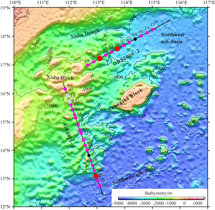
为了探明南海西北次海盆地壳结构,2006年9—10月,国家海洋局第二海洋研究所与中国科学 院南海海洋研究所合作,平行于南海西北次海盆残余扩张脊方向布设并实施了一条深地震测线OBS2006-2(图 1),实验中使用了12台海底地震仪(OBS),均为德国产的Sedis IV型短周期自浮式四分量OBS(李湘云等,2007; 吴振利等,2008),实验较为成功,仅丢失1台OBS(OBS09),成功率为92%,获得了沿残余扩张脊方向的第一手资料,OBS2006-2测线下方的速度结构为南海西北部陆缘的拉张与南海的形成演化提供了重要的科学依据(敖威等,2012).

|
图 1 OBS2006-2和OBS973-3测线区域位置及OBS台站分布.测线上红色大圆圈为数据异常台站,灰色圆圈为无数据台站,黑色圆圈为丢失台站,粉色圆圈为正常台站 Fig. 1 Bathymetric map and shaded-relief image of the Northwest and Southwest sub-basins of the South China Sea with 1000 and 3000 m isobaths. Locations of the seismic lines OBS2006-2 and OBS973-3. The red, gray, black and pink circles represent OBSs with abnormal data, with no data, lost stations, and normal stations, respectively |
 2016, Vol. 59


