2. 中国地质科学院地质研究所, 北京 100037
2. Institute of Geology, Chinese Academy of Geological Sciences, Beijing 100037, China
在华北克拉通与西伯利亚板块之间的兴蒙造山带是世界上最宽阔、发展历史最长、构造岩浆活动最复杂的一条巨型增生造山带,属于中亚造山带的东段.它包含很多微陆块,还发育三条蛇绿岩带,并且构造发育,岩浆活动强烈.多数学者应用板块构造理论确定了一系列反映板块构造相互作用的证据,包括蛇绿岩、蓝片岩及与板块俯冲、碰撞有关的火山-深成岩带,认为兴蒙造山带不是华北板块与西伯利亚板块之间的简单缝合带,而是位于两大板块之间的中、小块体群组成的构造拼合带(胡骁等,1991;王荃等,1991;邵济安,1991;邵济安等,1991;李双林等,1998;崔盛芹,1999).在显生宙期间,兴蒙造山带先后经历了古亚洲洋俯冲闭合、陆陆汇聚及碰撞后伸展等地质过程(Xiao et al,2003,2004,2009;Yakubchuk A,2004;Sengoramc et al.,2004;Jahn,2004),地质学家们提出了多种构造演化模型(Chen et al.,2009;Jian et al.,2008;Kroner et al,2007,2013;Li et al.,2006;Sengor et al,1993,2007;Xiao et al.,2009;Xu et al.,2013),至今未取得一致的共识.诸如,华北克拉通与西伯利亚板块碰撞缝合线位置,古亚洲洋最终闭合的时限和缝合带的空间展布,区域性伸展对地壳深部结构的改造等问题.以往前人的地球物理学科研成果主要集中在京津唐张邻区及渤海湾地区(周雪松等,1997;嘉世旭等,1995;张先康等,1996;祝治平,1997,1999;聂文英等,1998;张成科等,1998;赖晓玲,2002,2004;杨卓欣等,2000;朱露培等,1990),其成果表明华北平 原地壳分为5层,地壳平均速度为6.25~6.4 km/s, 莫霍面的深度约为38~43 km,华北平原的莫霍面的深度约为32~34 km,上地幔顶部Pn波的速度约为7.9~8.1 km/s.前人的科研成果主要是集中在华北板块,如本文这样始于华北板块北缘,横穿兴蒙造山带,直至西伯利亚板块南缘的地震剖面尚属首次.
2009—2010年在SinoProbe-02项目资助下,中国地质科学院地质研究所、国土资源实物地质资料中心等单位,在张家口—二连—中蒙边界实施了深地震反射、三分量反射及宽角反射与折射联合探测实验(简称SinoProbe-02华北联合地震探测实验),地震测线由南至北依次经张家口、张北、化德、镶黄旗、苏尼特右旗、二连浩特到中蒙边界,总长约600 km.本文对采集的8炮(1500 kg)宽角反射与折射资料进行了分析、处理和解释,获得了该区的二维地壳速度结构,探讨了华北板块和西伯利亚板块碰撞缝合带的位置,具有重要的意义.
2009—2010年在中国华北北部至中蒙边界地区利用宽角反射与折射地震方法,进行了深部地壳速度结构的探测工作.深地震测深的测线沿北西—南东方向布设,长约600 km.南起河北省张家口市,经张北县、化德县、内蒙苏尼特右旗、二连浩特、查干敖包、红格尔,终止于中蒙边界附近(图 1).
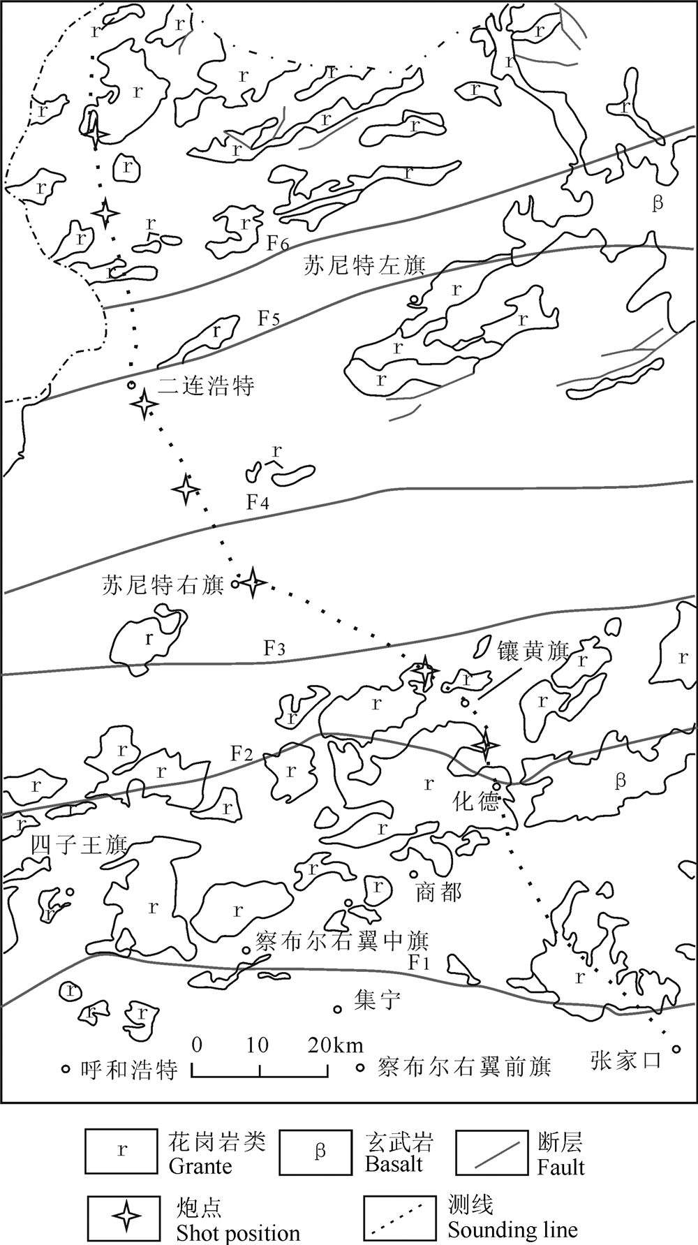 |
图1 深地震测深测线与地质构造图 F1 赤诚—平泉断裂带;F2 赤峰断裂带;F3 西拉木伦河断裂带;F4 索伦敖包—阿鲁科尔沁旗断裂带;F5 二连—贺根山深断裂带;F6 查干敖包—阿荣旗深断裂带. Fig.1 Geological map and deep seismic sounding line F1 Chicheng-Pingquan Fault Belt;F2 Chifeng Fault Belt;F3 The Xar Moron River Fault Belt;F4 Soren obo-Alukerqinqi Fault Belt;F5 Erlianhot-Hegenshan Fault Belt;F6 Chagan Obo-Arun Fault Belt. |
沿测线布设8个炮点,分别是化德县北炮点、镶黄旗北炮点、苏尼特右旗炮点、苏尼特右旗北炮点、二连浩特南炮点、二连浩特北炮点、洪格尔南炮点、洪格尔北炮点.每炮药量均为1500 kg.观测系统见图 2,炮点参数见表 1.
| 表1 深地震测深炮点位置 Table 1 Explosion position of deep seismic sounding profile |
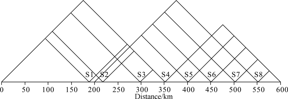 |
图2 部深地震测深观测系统 Fig.2 Deep seismic sounding observation system diagram |
在河北张家口—内蒙二连浩特—中蒙边境南北方向上,横亘三个迥然不同的一级构造单元,由南至北分别是华北板块、兴蒙造山带和西伯利亚板块(内蒙古地质矿产局,1991)(图 3).其中,兴蒙造山带的形成大致经历了由大洋板块俯冲到大陆板块碰撞拼合,再到后造山构造塌陷和拉张的构造演化过程(洪大卫等,2000).兴蒙造山带是华北板块和西伯利亚板块的缝合带,兴蒙造山带包含很多微陆块(李双林等,1998),还发育三条蛇绿岩带(黄金香等,2006),带内构造发育,岩浆活动强烈(图 3).兴蒙造山带独特而又复杂的地质背景引发了很多学者对该地区地质问题的争议.最强烈的争议在于华北板块和西伯利亚板块碰撞缝合线位置问题,目前有4种认识:
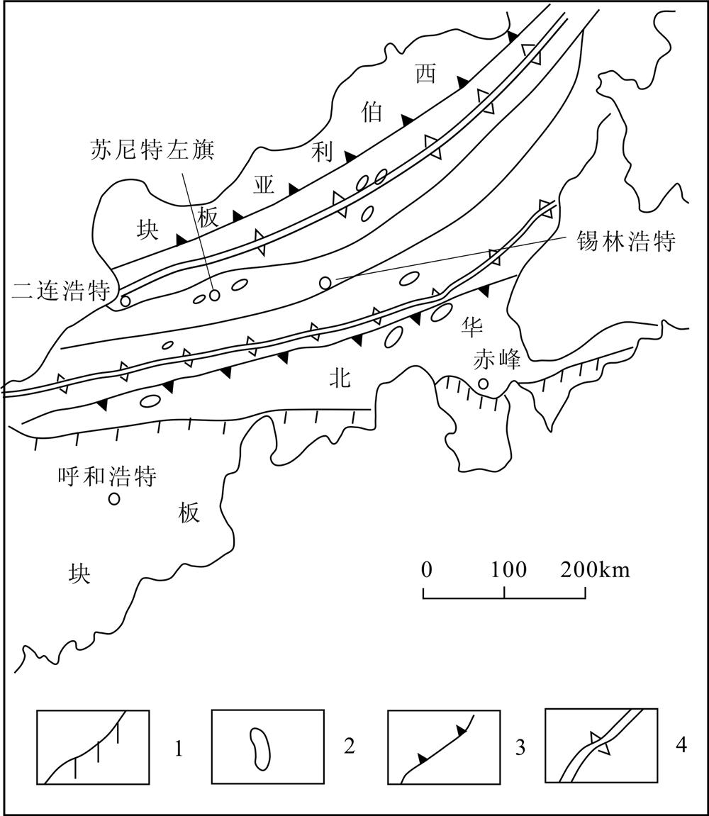 |
图3 研究区大地构造图(据黄金香,2006,略改) 1板块与造山带的界限;2蛇绿岩带;3俯冲带;4板块缝合带. Fig.3 Tectonic map of the study area(Modified from Huang Jinxiang et al.,2006) 1 The boundaries of plate and orogenic;2 Ophiolite belt;3 Subduction zone;4 Plate Suture zone. |
刘长安等(1979)认为这两大构造单元的分界位于蒙古人民共和国中部, 即所谓的蒙古弧, 其碰撞时代在早古生代的后期.
黄汲清等(1980)认为内蒙古的西拉木伦河深断裂是这两大板块的分界,最南部赤峰、化德以南地区属中朝地台的一部分,而南部的奈曼旗至温都尔庙一带是加里东褶皱带,中部和北部地区则属于华力西褶皱带.
马醒华等(1993)认为将华北地块与西伯利亚板块的最后拼合边界定在西拉木伦河一带是值得商榷的,应该将这一边界向北推移至蒙古—鄂霍次克一带, 甚至到更北边的西伯利亚南缘断裂带.
王荃等(1986)认为在华力西褶皱带中存在一条晚古生代板块缝合线,位于西拉木伦河谷以北约60 km的林西县八棱山—盖家店至克什克腾旗的黄岗梁一带.二者拼接的时代可能是二叠纪晚期.其南属中朝古板块,其北则属西伯利亚古板块(李春昱等,1982;王荃,1986) .由此将内蒙古古生代褶皱带支解为二:在缝合线以南实际是华北板块北缘的造山带, 而其北侧的内蒙古广大地区则是西伯利亚板 块南缘的造山带(王荃,1986).刘正宏等(2000)、 张臣(2004)、Li(2006)、李益龙等(2009,2010,2012)认为华北地块与西伯利亚板块的最后拼合边界位于林西—长春一带,与王荃(1986)的结果一致.这个位置大概在索伦敖包—阿鲁科尔沁旗断裂带(F4)附近.
在地震记录截面上,本文识别出6个震相:Pg震相为基地界面之上的回折波,P2震相为上地壳底面的宽角反射波,P3震相为中地壳内的宽角反射波,P4震相为中地壳底面的宽角反射波,P5震相为下地壳内的宽角反射波,仅在镶黄旗—苏尼特右旗下方出现,Pm震相为莫霍面(Moho)的宽角反射波(图 4).图 4中的滤波频率为1~12 Hz,折合速度为6 km/s.图 5为洪格尔南(S7)炮-20~60 km的反射地震记录截面图.图 4、5中方框为理论计算拟合的地震波到时,曲线为拾取的地震波到时.
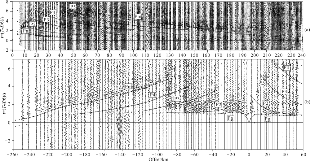 |
图4 苏尼特右旗(S3)(a)和洪格尔南(S7)(b)炮的地震记录截面 Fig.4 The sections of the vertical component records of S3 (a) in Suniteyouqi and S7 (b) in the south of Honggeer |
比较图 4的下图和图 5发现,在相同的接收段-20~60 km,宽角反射/折射地震方法与深反射地震方法记录的地震波(Pg)到时基本一致.
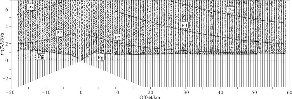 |
图5 洪格尔南(S7)炮的反射地震记录截面 Fig.5 The sections of the reflection seismic records of S7 in the south of Honggeer |
Pg波为地震记录截面上的回折初至波,能量都很强,容易追踪、识别.S1、S2炮的Pg波走时最小,反映出华北板块、内蒙造山带的浅层速度较大,平均视速度为4.3~6.0 km/s .S3、S4、S5炮的Pg波走时较大,反映出苏尼特右旗—二连盆地的浅层速度最小,平均视速度为3.1~5.4 km/s.S5、S6炮的Pg走时反映出二连盆地与西伯利亚板块过渡带的浅层速度特点,平均视速度为4.26~5.5 km/s.S7、S8 炮的走时变大,反映出西伯利亚板块的浅层速度较小,平均视速度为3.4~5.5 km/s(见表 2).
| 表2 各炮Pg波震相的追踪距离、走时范围和视速度 Table 2 The tracking distance and travel time range, the apparent velocity of Pg-waves seismic phases |
P2震相为上地壳底面的宽角反射波,在近距离是续至波,60 km之后为初至波,可以有效追踪、识 别.S1、S2炮的平均速度最大,反映了华北板块、内 蒙造山带上地壳速度特点,平均速度为5.75~5.82 km/s. S3、S4、S5炮的平均速度最小,反映了苏尼特右旗—二连盆地的速度特点,平均速度为5.6~5.7 km/s.S5、S6炮的平均速度反映了二连盆地与西伯利亚板 块过渡带的速度特点,平均速度为5.65~5.76 km/s. S7、S8炮的平均速度反映了西伯利亚板块的速度特点,平均速度为5.7~5.75 km/s(见表 3).
| 表3 各炮P2、P3、P4、Pm震相的追踪距离、平均速度和振幅能量 Table 3 The tracking distance,average velocity and amplitude of energy of P2、P3、P4、Pm-waves seismic phases |
P3震相为中地壳内的宽角反射波,在近距离是续至波,80 km之后为初至波,可以有效追踪、识别.S1、S2、S3炮记录反映了华北板块、内蒙造山带上地壳速度特点,平均速度为6.0~6.06 km/s .S3、S4、S5炮反映了苏尼特右旗—二连盆地的地震波速度 特点,平均速度为5.95~6.0 km/s.S6、S7、S8炮反映了 西伯利亚板块的速度特点,平均为6.0~6.05 km/s(表 3).
P4震相为中地壳底面的宽角反射波,在近距离是续至波,110 km之后为初至波,可以有效追踪、识别.S1、S2炮记录反映了华北板块、内蒙造山带上地壳速度特点,平均速度为6.18~6.2 km/s .S3、S4、S5炮的平均速度最小,反映了苏尼特右旗—二连盆 地的速度特点,平均速度为6.1~6.15 km/s.S6、S7、S8炮反映了西伯利亚板块的速度特点,平均速度为6.17~6.21 km/s(表 3).
P5震相为下地壳内的宽角反射波,仅在S3、S4炮地震记录上出现,在近距离是续至波,120 km之后为初至波,可以追踪、识别.S3炮追踪距离70~ 170 km,能量偏弱,初至不明显,平均速度为6.25 km/s. S4炮追踪距离90~200 km,能量较强,初至明显,平均速度为6.26 km/s.在160 km之后为初至波.主要反映了内蒙造山带下方地壳的变化特征.
Pm震相为莫霍面(Moho)的宽角反射波,Pm震相的临界反射位置在90~100 km左右.在近距离是续至波,160 km之后为初至波,可以有效追踪、识别.地壳的平均速度为6.3~6.4 km/s(表 3).沿剖面的所有记录截面图中未识别出莫霍面首波Pn.
张家口—中蒙边境的二维速度结构是在震相识别的基础上建立的,并以测线通过地形最高点的高程1553 m为模型零点,构制了剖面的初始二维地壳模型.正演拟合计算采用基于地震波的渐近射线理论方法(Cerveny et al.,1982),由Seis88程序对各炮拾取的到时进行了拟合, 通过不断修改反射界面深度和层速度,逐步改进初始二维速度结构.并在同一、二维速度结构模型中,逐步完成8炮、每炮6个震相的地震波到时拟合,达到满意的程度,限制模型的多解性(图 7a,b).
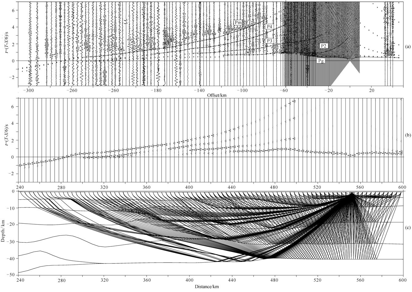 |
图6 洪格尔北(S8)炮的震相走时拟合(a)、理论地震图(b)和射线追踪综合图(c) Fig.6 Seismic travel time fitting (a) synthetic seismograms (b) and ray tracing diagram of S8 in the north() of Honggeer |
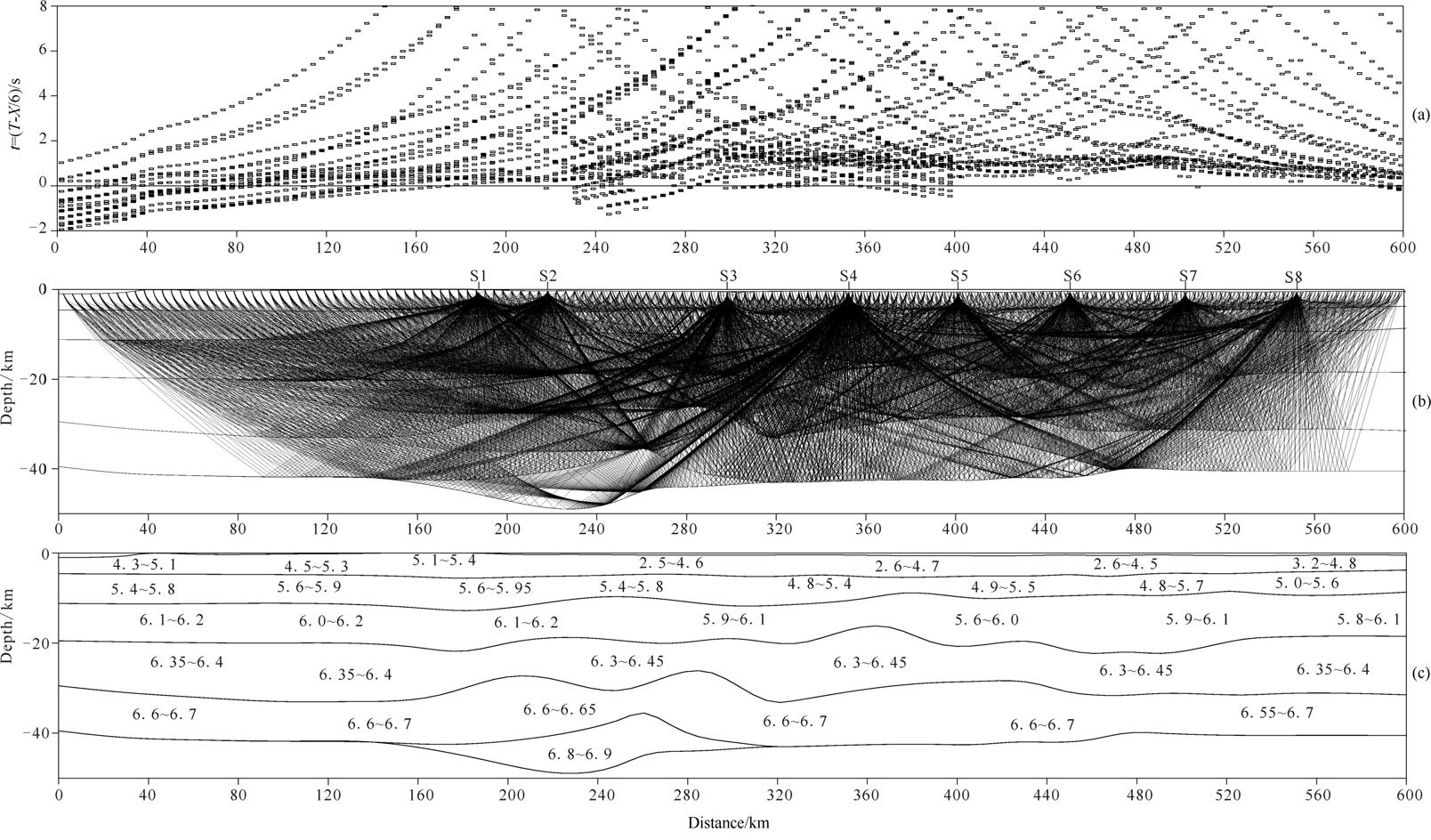 |
图7 炮集的地震走时拟合(a)、射线覆盖(b)和简化的速度模型图(c)(图c中数字单位为km/s) Fig.7 The diagram of seismic travel time fitting (a), ray cover of the shot gathers (b) and the simplified velocity model(c) |
图 6为内蒙边境附近洪格尔北S8炮的地震波走时拟合(a)、理论地震图(b)和射线路径(c).图 7为沿剖面的炮集震相走时拟合(a)、炮集射线覆盖(b)和简化的速度模型(c).
控制各震相到时的拟合误差小于0.05 s,莫霍面等界面深度的误差小于0.5~1.0 km,速度误差小于0.02~0.05 km/s,最终获得了沿剖面的二维速度结构(图 8).
图 8a显示了沿测线的地名、主要断裂位置和地质构造单元分带特征,图左侧是华北板块,中间是内蒙造山带,右侧是西伯利亚板块.地表上华北板块与内蒙造山带的分界是温都尔庙—西拉木伦河断裂带(F3),内蒙造山带与西伯利亚板块的分界是查干敖包—阿荣旗深断裂带(F6). 图 8b显示了测线通过的地表高程、基底界面、上地壳底面和不同地质构造单元(华北板块、内蒙造山带、西伯利亚板块)的上地壳速度等值 线变化特征.图 8c显示了整个地壳的速度结构特征.
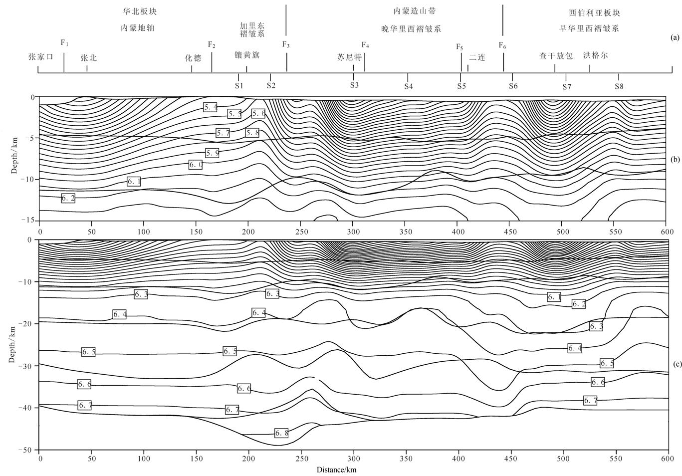 |
图8 张家口至中蒙边境的纵波二维速度结构(图中数字单位为km/s) Fig.8 Two-dimensional structure of the crust from Zhangjiakou to China-Mongolia border |
图 8中显示固结地壳为5层结构,在化德北至苏尼特右旗为6层.第1个界面为Pg波终止位置界面(基底界面),下面5个界面,分别是震相分析中P2、P3、P4、P5、Pm宽角反射震相的反射界面.在3个不同构造单元内,不同界面的深度与层速度变化特点见表 4.
图 8和表 4的结果表明,沿整个地震剖面,三个构造单元的地壳速度结构变化明显,在上地壳华北板块的速度最大,界面深度最深,在加里东褶皱带下方界面下凹,在内蒙地轴下方界面平缓.西伯利亚板块的速度最小,界面深度最浅,且平缓.内蒙造山带的速度和界面深度变化介于二者之间,界面明显起伏.在化德南到镶黄旗北部的岩浆岩出露区,上地壳的速度明显增大,地表速度为5.4 km/s,底部达到6.2 km/s, 界面深度最深.在苏尼特左旗—二连盆地的速度最低,地表为3.4 km/s,底部为6.0 km/s.北部洪格尔周围的速度范围为3.6~6.0 km/s,界面深度最浅.
| 表4 地壳速度结构参数汇总 Table 4 Summary for the parameters of crustal velocity structure |
中地壳西伯利亚板块的速度最小,深度最深.内蒙造山带的速度大于西伯利亚板块的速度,界面深度最小,起伏剧烈.华北板块的速度最大,界面深度大于内蒙造山带的深度.在赤峰断裂带(F2)以南的华北板块的反射界面比较平缓,以北明显上隆.在内蒙造山带反射界面变化剧烈,起伏较大(F3与F6之间).在西伯利亚板块反射界面较为平缓,查干敖包下方界面下凹.
下地壳的底面(莫霍面)具有自北向南逐渐增深的特点,在F3断裂带下方最深为47 km.西伯利亚板块的速度最大,莫霍深度最浅.内蒙造山带的莫霍面深度最深,速度最小.华北板块的速度大于内蒙造山带的速度,莫霍面深度小于内蒙造山带的莫霍面深度.在断裂F2与F4之间,华北板块与内蒙造山带过渡区域(化德—苏尼特),莫霍面1明显上隆,深度 为33.5 km,层速度为6.6~6.7.莫霍面2明显下凹,最深达到47 km,速度最大达到6.7~6.9 km/s, 可能是壳幔物质组成的混合体,在该区域(图 1)地表上广泛出露花岗岩及蛇绿岩.本文结果与内蒙古东乌珠穆沁旗—辽宁东沟地学断面的结果(卢造勋等,1993a、1993b)相比,存在着莫霍面深度大,速度低和没有明显Pn震相的特点.
多年来,许多著名的地质学家对该区的大地构造单元划分和归属进行了论述(李春昱,1980;黄汲清等,1994;王荃等,1991;王楫等,1993;胡骁等,1990;洪作民,1994;程裕淇等,1994) ,内蒙古中部的蛇绿岩带被认为是古亚洲洋东部封闭后残留的大洋岩石圈残片,三条蛇绿岩带被认为是华北板块和西伯利亚板块之间的缝合带,由南向北分别是温都尔庙—西拉木伦河蛇绿岩带、索伦山苏左旗—锡林浩特蛇绿岩带和二连浩特—贺根山蛇绿岩带, 其年龄也依次变新.内蒙古中部蛇绿岩带中存在洋岛玄武岩和大洋岛弧玄武岩.洋岛玄武岩的存在说明古亚洲洋曾发育洋盆,大洋岛弧玄武岩的存在说明古亚洲洋内部存在大洋岩石圈之间的俯冲作用,伴随着大洋的消亡,该区进入陆陆碰撞造山阶段,形成了举世瞩目的兴蒙造山带;而后进入中生代,燕山运动标志着南北对接历史的结束和环太平洋构造演化的开始,该区由碰撞进入了伸展作用,对兴蒙造山带有改造作用.
从总体上观察整个地壳结构,在华北板块与内蒙造山带之间,内蒙造山带与西伯利亚板块之间,上地壳存在明显的速度局部变化,在相应的区域地表发育大量的古生代花岗岩体、超基性岩体.中 下地壳在华北板块南缘的速度大,为6.3~6.7 km/s, 西伯利亚板块北缘的速度小,为6.1~6.7 km/s,总趋势上速度变化比较均匀,界面比较平缓.
在内蒙造山带内,中下地壳的界面起伏剧烈,并伴有地壳速度的明显变化,速度的不均匀造成了速度等值线的起伏变化.在地质上,内蒙造山带的形成背景是古亚洲洋的闭合,经历了大洋板块俯冲、大陆板块碰撞拼合,以及后造山构造塌陷和拉张的构造演化过程,从而形成了现今主要呈现南北挤压特征的大规模近东西向的弧形造山带.在整个造山过程中,地壳的缩短和隆升造山引起了中下地壳界面的剧烈起伏,不同海陆块的拼合和物质交换导致了不同区域的速度不均匀性.
沿剖面的莫霍面特征表明:赤峰断裂带(F2)以南华北板块和索伦敖包—阿鲁科尔沁旗断裂带(F4)以北西伯利亚板块,莫霍面比较平缓,平均深度为40~42 km.在F2—F4之间呈双莫霍面特点, 莫霍面1明显上隆,深度为33.5 km,层速度为6.6~6.7. 莫霍面2明显下凹,在西拉木伦河断裂带(F3)下方,最深达到47 km,速度达到最大,为6.8~6.9 km/s,可能是在地壳俯冲、碰撞中,由壳幔物质形成的混合体,在地表上广泛出露花岗岩及蛇绿岩体.总之,依据本区莫霍面的表现特点,可以认为双莫霍面以南是华北板块北缘造山带,以北是西伯利亚板块南缘造山带.
本文从深地震测深的角度入手,探讨两大板块最终拼合的位置及该区的深部结构特征.依据图 8中的地壳结构特点,本文最终认为华北地块与西伯利亚板块的最后拼合位置在赤峰断裂带(F2)与索伦敖包—阿鲁科尔沁旗断裂带(F4)之间的区域.
| [1] | Bureau of Geology and Mineral Resources of Inner Mongolia. 1991. Inner Mongolia Autonomous Regional Geology(in Chinese). Beijing: Geological Publishing House. |
| [2] | Cerveny Y, Molotkov I A, Psencik I,et al. 1982. Ray Method of Seimology. Beijing: Geological Publishing House. |
| [3] | Chen B, Jahn B M, Tian W. 2009. Evolution of the Solonker suture zone: constraints from zircon U-Pb ages, Hf isotopic ratios and whole-rock Nd-Sr isotope compositions of subduction-and collision-related magmas and forearc sediments. J. Asian Earth Sci. ,34:245-257. |
| [4] | Cheng Y Q.1994. Concise Regional Geology of China(in Chinese). Beijing: Geological Publishing House. |
| [5] | Cui S Q.1999. On global Meso-Cenozoic intracontinental orogenesis and orogenic belts. Earth Science Frontiers(in Chinese), 6:283-293. |
| [6] | Hong D W, Wang S, Xie X L, et al.2000. Genesis of positive ε(Nd,t) granitoids in the Da Hinggan MTS.-Mongolia orogenic belt and growth continental crust. Earth Science Frontiers(in Chinese), 7(2):441-456. |
| [7] | Hong Z M.1994.Crustal movements and structures on the northern margin of North China Plate in the Middle to Late Proterozoic Period. Geology of Chemical Minerals(in Chinese), (3): 145-153. |
| [8] | Hu Y, Xu C S, Niu S Y. 1990.Tectonic Evolution of Continental Margin of North China Carton in the Early Paleozoic(in Chinese). Beijing: Beijing University Press. |
| [9] | Huang J Q, Ren J S, Jiang C F et al.1980.Tectonics and Evolution of China (in Chinese). Beijing: Science Press. |
| [10] | Huang J Q, Ren J S,Jiang C F et al.1994.Some new observations on the geotectonic characteristics of China. Acta Geological Sinica(in Chinese), 48(1): 36-521. |
| [11] | Huang J X, Zhao Z D, Zhang H F,et al. 2006. Elemental and Sr-Nd-Pb isotopic geochemistry of the Wenduermiao and Bayanaobo-Jiaoqier ophiolites, Inner Mongolia: Constrains for the characteristics of the mantle domain of eastern Paleo-Asian Ocean. Acta Perologica Sinica(in Chinese), 22(12):2889-2900. |
| [12] | Jahn B M. 2004. Phanerozoic continental growth in central Asia. Journal of Asian Earth Sciences,23:599-603. |
| [13] | Jia S X, Liu C Q.1995. Study on the seismic phase of DSS in North China. Seismology and Geology(in Chinese), 17(2):111-113. |
| [14] | Jian P, Liu D Y, Kroner A,et al. 2008. Time scale of an early to mid-Paleozoic orogenic cycle of the long-lived Central Asian orogenic belt, Inner Mongolia of China: implications for continental growth. Lithos,101:233-259. |
| [15] | Kroner A, Kovach V, Belousova E,et al. 2013. Reassessment of continental growth during the accretionary history of the Central Asian Orogenic Belt. Gondwana Res. ,25:103-125. |
| [16] | Kroner A, Windley B F, Badarch G,et al. 2007. Accretionary growth and crust formation in the Central Asian Orogenic Belt and comparison with the Arabian-Nubian shield. //In: Hatcher R D, Carlson M P, McBride, J H, Martinez Catalan J R eds. 4-D Framework of Continental Crust. Mem. Geol.Soc. Am. , 200:181-209. |
| [17] | Lai X L, Li S L, Zhang X K,et al. 2002. 3-D structural feature in Zhangbei earthquake region. Earth Science Frontiers (in Chinese), 9(4): 383-388. |
| [18] | Lai X L, Zhang X K, Cheng S X,et al.2004. Study on crust mantle transitional zone in west margin of Zhangjiakou-Bohai fault belt. Acta Gophysica Sinica(in Chinese), 47(5): 798-804. |
| [19] | Li C Y. 1980. A preliminary study of plate tectonic of China. Bulletin Chinese Acad. Geol. Sci. , Series Ⅰ(in Chinese), 2(1): 11-201. |
| [20] | Li C Y, Wang Q, Liu X Y,et al.1982. Asian Tectonic Map and Instructions(in Chinese). Beijing: Geological Publishing House. |
| [21] | Li J Y. 2006. Permian geodynamic setting of Northeast China and adjacent regions: closure of the paleo-Asian Ocean and subduction of the Paleo-Pacific Plate. Journal of Asian Earth Sciences, 26(3-4): 207-224. |
| [22] | Li S L, Ouyang Z Y. 1998. Tectonic framework and evolution of Xing Anling-Mongolian orogenic belt and its adjacent region. Marine Geology and Quaternary Geology(in Chinese), 18(3):45-54. |
| [23] | Li Y L, Zhou H W, Zhong Z Q, et al. 2009. Collision processes of North China and Siberian Plates: evidence from LA-ICPMS zircon U-Pb age on deformed granite in Xar Moron suture zone. Earth Science—Journal of China University of Geosciences(in Chinese), 34(6):1-8. |
| [24] | Li Y L, Zhou H W, Zhong Z Q, et al. 2010.Extension of suture zone between North China and Siberia Craton in Early Cretaceous: insights from geochronology and geochemistry of intermediate dykes from Xar Moron fault belt in Inner Mongolia. Earth Science—Journal of China University of Geosciences(in Chinese), 35(6):921-932. |
| [25] | Li Y L, Zhou H W, Zhong Z Q, et al. 2012.Superposition of Paleo-Asian and West-Pacific tectonic domains in the eastern section of the Solonker Suture zone: insights from petrology, geochemistry and geochronology of deformed diorite in Xar Moron fault zone, Inner Mongolia. Earth Science—Journal of China University of Geosciences(in Chinese), 37(3):433-450. |
| [26] | Liu C A, Shan J C.1979. Basic characteristics of Mongolia-Okhotsk Sea plate tectonics. Journal of Changchun College of Geology(in Chinese), (2):1-13. |
| [27] | Liu Z H, Liu Y Q, Feng B Z. 2000.The establishment and tectonic evolution of proterozoic orogenic belt in the north margin of North China Plate. Journal of Changchun University of Science and Technology(in Chinese),30 (20):110-114. |
| [28] | Lu Z X, Xia H K. 1993a. Geoscience transect from Dong U JimQinqi, Nei Mongol, to Donggou, Liaoning, China. Acta Gophysica Sinica(in Chinese), 36(6):765-772. |
| [29] | Lu Z X, Xia H K, Zhao G M, et al.1993b. Synthetic geophysics feature of geoscience transection from Dong U Jimqin Qi, Nei Mongol to Donggou, Liaoning. Seismologcical Research of Northeast China(in Chinese), 9(2):1-12. |
| [30] | Ma X H, Yang Z Y. 1993.The collision and suturing of the three major blocks in China and the reconstruction of the Paleo-Eurasia Continent. Acta Geophysica Sinica(in Chinese), 36(4):476-488. |
| [31] | Nie W Y, Zhu Z P, Zhang X K, et al.1998.The crustal mantle tectonics and its velocity structure revealed by the refraction profile passing through the west edge of the Zhangjiakou- Bohai seismic belt. Journal of Seismological Research (in Chinese), 21(1): 94-102. |
| [32] | Sengor A M C, Natalin B A.1996. Paleotectonics of Asia: fragments of a synthesis. //In:Yin A, Harrison M eds. The Tectonic Evolution of Asia. 486-641. |
| [33] | Sengor A M C, Natalin, B A, Burtman V S.1993. Evolution of the Altaid tectonic collage and Palaeozoic crustal growth in Eurasia. Nature, 364: 299-307. |
| [34] | Shao J A.1991.Crust Evolution in the Middle Part of the Northern Margin of Sino-Korean Plate (in Chinese). Beijing: Beijing University Press. |
| [35] | Shao J A, Tang K D, Wang C Y, et al.1991. The tectonic characteristics and evolution of the Dan Hada terrane. Science in China (Series B), (7): 744-751. |
| [36] | Wang J, Li S Q. 1993.Langshan: Rift System of Bayan Obo(in Chinese). Beijing: Beijing University Press. |
| [37] | Wang Q. 1986. Recognition of the suture between the Sino-Korean and Siberian Paleoplates in the middle part of Inner Mongolia. Acta Geologica Sinica, 1:32-43. |
| [38] | Wang Q, Liu X Y, Li J Q.1991.Plate Tectonics Between Cathysia and Angaraland (in Chinese). Beijing: Beijing University Press. |
| [39] | Windley B F, Alexeiev D, Xiao W, et al.2007. Tectonic models for accretion of the Central Asian Orogenic Belt. J. Geol. Soc. 164: 31-47. |
| [40] | Xiao W, Kroner A, Windley B.2009. Geodynamic evolution of central Asia in the Paleozoic and Mesozoic. Int. J. Earth Sci. , 98:1185-1188. |
| [41] | Xiao W, Windley B F, Hao J, et al. 2003. Accretion leading to collision and the Permian Solonker suture, Inner Mongolia, China: Termination of the Central Asian Orogenic Belt. Tectonics, 22:1069. |
| [42] | Xiao W J, Windley B F,Badarch G, et al. 2004. Paleozoic accretionary and convergent tectonics of the southern Altaids: implications for the growth of Central Asia. Journal of the Geological Society, 161:339-342. |
| [43] | Xiao W J, Windley B F,Hao J, et al.2003. Accretion leading to collision and the Permian Solonker suture, Inner Mongolia, China: termination of the central Asian orogenic belt. Tectonics,22.doi:10. 1029/2002TC001484. |
| [44] | Xiao W J, Windley B F,Huang B C, et al. 2009. End-Permian to mid-Triassic termination of the accretionary processes of the southern Altaids: implications for the geodynamic evolution, Phanerozoic continental growth, and metallogeny of Central Asia. International Journal of Earth Sciences, 98:1189-1217. |
| [45] | Xu B, Charvet J, Chen Y, et al.2013. Middle Paleozoic convergent orogenic belts in western Inner Mongolia (China): framework, kinematics, geochronology and implications for tectonic evolution of the Central Asian Orogenic Belt. Gondwana Res. , 23 (4):1342-1364. |
| [46] | Yakubchuk A. 2004. Architecture and mineral deposit settings of the Altaid orogenic collage: a revised model. Journal of Asian Earth Sciences, 23:761-779. |
| [47] | Yang Z X, Zhao J R, Zhang X K, et al.2000. Structure of Moho in North China —3-D inversion from deep seismic sounding data. Seismolgy and Geology ( in Chinese) , 22 (1) :74-80. |
| [48] | Zhang C, Liu S W, He G Q, et al.2004. Characteristics and their tectonic environment of Late Mesoproterozoic granitoids in the middle segment of north margin of the North China Plate. Acta Scientiarum Naturalium Universitatis Pekinensis, 40(2):232-240. |
| [49] | Zhang C K, Zhang X K, Ge Y J, et al. 1998. The crust-mantle velocity structure and deep tectonics in the Datong-Yanggao seismic region and its adjacent area. Seismology and Geology (in Chinese), 20(4): 391-398. |
| [50] | Zhang X K,Wang C Y, Liu G D, et al.1996. Fine crustal structure in Yanqing-Huailai region by deep seismic. Acta Geophysica Sinica, 39(3):356-364. |
| [51] | Zhou X S, Song S Y, Zhang X K, et al. 1997.Interpretation of S-wave date from Fanshi Taipusiqi DSS profile and analysis of correlation between deep structural characteristics and seismicity. Earthquake Research in China (in Chinese), 13(3): 253-262. |
| [52] | Zhu L P, Zong R S, Liu F T.1990. Three-dimensionl P-wave velocity structure under the Beijing network area. Acta Geophysica Sinica, 33(3): 267-277. |
| [53] | Zhu Z P, Zhang X K, Zhang J S, et al.1997. The research of tectonics and mantle velocity structure of the crust from Beijing to Fengzhen. Acta Seismologica Sinica, 19(5):499-505. |
| [54] | Zhu Z P, Zhang J S, Zhang X K, et al. The crust mantle structure in Zhangbei Shangyi earthquake area. Earthquake Research in China, 15(1): 65-73. |
| [1] | 程裕淇.1994.中国区域地质概论. 北京: 地质出版社. |
| [2] | 崔盛芹.1999.论全球性中—新生代陆内造山作用与造山带. 地学前缘, 6:283-293. |
| [3] | 洪大卫, 王式, 谢锡林等. 2000. 兴蒙造山带正ε(Nd,t)值花岗岩的成因和大陆地壳生长.地学前缘, 7(2): 441-456. |
| [4] | 洪作民. 1994. 华北地台北缘中晚元古代地壳运动. 化工地质, (3):145-153. |
| [5] | 胡骁, 许传诗, 牛树银. 1990. 华北地台北缘早古[JP3]生代大陆边缘构造演化.北京: 北京大学出版社. |
| [6] | 黄汲清,任纪舜,姜春发等.1980.中国大地构造及其演化.北京:科学出版社. |
| [7] | 黄汲清,任纪舜,姜春发等.1994.对中国大地构造若干特点的新认识. 地质学报, 48(1):36-521. |
| [8] | 黄金香,赵志丹,张红飞等.2006.内蒙古温度尔庙和巴彦敖包—交其尔蛇绿岩的元素与同位素地球化学:对古亚洲洋东部地幔域特征的限制. 岩石学报,22(12):2889-2900. |
| [9] | 嘉世旭,刘昌铨.1995.华北地区人工地震测深震相与地壳结构研究. 地震地质,17(2):111-113. |
| [10] | 赖晓玲,李松林,张先康等.2002.张北地震区三维构造特征. 地学前缘, 9(4): 383-388. |
| [11] | 赖晓玲,张先康,成双喜等.2004.张家口—渤海断裂带西缘壳幔过渡带研究. 地球物理学报,47(5):798-804. |
| [12] | 李春昱.1980.中国板块构造轮廓. 中国地质科学院院报,2(1): 11-201. |
| [13] | 李春显,王荃,刘雪亚等.1982.亚洲大地构造图(1∶80万) 及说明书.北京:地图出版社. |
| [14] | 李双林,欧阳自远.1998.兴蒙造山带及临区的构造格局与构造演化. 海洋地质与第四纪地质,18(3):45-54. |
| [15] | 李益龙,周汉文,钟增球等.2009.华北与西伯利亚板块的对接过程:来自西拉木伦缝合线变形花岗岩锆石的LA-ICPMS U-Pb年龄证据.地球科学—中国地质大学学报,34(6):1-8. |
| [16] | 李益龙,周汉文,钟增球等.2010.华北—西伯利亚板块对接带早白垩纪的裂解:来自西拉木伦断裂带中性岩墙群的锆石U-Pb年龄及地球化学证据. 地球科学—中国地质大学学报,35(6):921-932. |
| [17] | 李益龙,周汉文,钟增球等.2012.古亚洲构造域和西太平洋构造域在索伦缝合线东段的叠加:来自内蒙古林西县西拉木伦断裂带内变形闪长岩的岩石学、地球化学和年代学证据. 地球科学—中国地质大学学报,37(3):433-450. |
| [18] | 刘长安,单际彩.1979.试谈蒙古—鄂霍茨克海带古板块构造的基本特征. 长春地质学院学报,(2)1-13 . |
| [19] | 刘正宏,刘雅琴,冯本智.2000.华北板块北缘中元古代造山带的确立及其构造演化. 长春科技大学学报,30(20):110-114. |
| [20] | 卢造勋,夏怀宽.1993a.内蒙古东乌珠穆沁旗—辽宁东沟地学断面. 地球物理学报,36(6):765-772. |
| [21] | 卢造勋,夏怀宽,赵国敏等.1993b.内蒙古东乌珠穆沁旗至辽宁东沟地学断面综合地球物理特征. 东北地震研究,9(2):1-12. |
| [22] | 马醒华,杨振宇.1993.中国三大地块的碰撞拼合与古欧亚大陆的重建. 地球物理学报,36(4):476-488. |
| [23] | 内蒙古自治区地质矿产局.1991.内蒙古自治区区域地质志.北京:地质出版社. |
| [24] | 聂文英,祝治平,张先康等.1998.穿过张家口—渤海地震带西缘的折射剖面所揭示的地壳上地幔构造与速度结构. 地震研究, 21(1):94-102. |
| [25] | 邵济安.1991.中朝板块北缘中段地壳演化.北京:北京大学出版社. |
| [26] | 邵济安,唐克东,王成源等.1991.那丹哈达地体的构造特征及其演化. 中国科学(B辑),(7):744-751. |
| [27] | 王楫, 李双庆.1993.狼山:白云鄂博裂谷系 .北京:北京大学出版社. |
| [28] | 王荃.1986.内蒙古中部中朝与西伯利亚古板块间缝合线的确定. 地质学报,1:32-43. |
| [29] | 王荃,刘学亚,李锦轶.1991.中国华夏与安加拉古陆间的板块构造 .北京:北京大学出版社. |
| [30] | 杨卓欣,赵金仁,张先康等.2000.华北莫霍面构造形态—深地震测深数据的三维反演. 地震地质,22(1):74-80. |
| [31] | 张臣,刘树文,何国琦等.2004.华北克拉通北缘中段中新元古代热-构造事件及其演化. 北京大学学报(自然科学版) ,40(2):232-240. |
| [32] | 张成科,张先康,盖玉杰等.1998.大同—阳高震区及其邻区壳幔速度结构与深部构造. 地震地质, 20(4):391-398. |
| [33] | 张先康,王椿镛,刘国栋等.1996.延庆—怀来地区地壳细结构利用深地震反射剖面. 地球物理学报, 39(3):356-364. |
| [34] | 周雪松,宋松岩,张先康等.1997.繁峙—太仆寺旗剖面S波资料解释及深部构造特征与地震相关性分析. 中国地震,13(3):253-262 |
| [35] | 朱露培,曾融生,刘福田.1990.京津唐张地区地壳上地幔三维P波速度结构. 地球物理学报,33(3):267-277. |
| [36] | 祝治平,张先康,张建狮等. 1997.北京—怀来—丰镇剖面地壳上地幔构造与速度结构研究.地震学报,19(5):499-505. |
| [37] | 祝治平,张建狮,张先康等.1999.张北—尚义地震区壳幔构造.中国地震,15(1):65-73. |
 2014, Vol. 57

