 2011, Vol. 54


2. 中海油研究总院,北京 100027
2. CNOOC Research Institute, Beijing 100027, China
时深转换[1~4]是地震-地质解释的必经环节,其准确度和精度直接影响到地震解释结果的优劣.基底是盆地基础地质研究的重要内容[5~7].但基底埋深大、钻遇井少,为钻井所揭示的基底层段通常很薄、远未达到基底研究所涉及到的深度.这些都给基底研究造成难以克服的困难[8~12],集中表现为基底研究所涉及深度的地震时深转换问题.即目前常规的时深转换都是VSP (Vertical Seismic Profiling)方法[13~16],钻井的时深数据是时深转换的必要条件,它是基于钻井获取的垂直反射地震双程反射时间与对应井深资料实现时深拟合.而对于钻井尚未达到的基底而言,时深转尺制作一般采用曲线下延方法加以解决1).
1) 杨宝俊,王璞臖,程日辉等.松辽盆地滨北构造特征与构造圈闭研究.中石油勘探先导项目研究报告和图册.2004
然而,在用时深转换的下延法研究珠江口盆地基底时,发现由此获得的岩层纵波速度与实际情况偏差较大.为此,提出深部下延段校正的VSP 时深转换方法,即首先用深井和钻遇基底井VSP 数据与研究区深部地层现有的所有时深数据重新拟合时深转换的二次多项式.由此得到的时深尺,其上部有效运用了VSP资料,下部有一系列深反射地震资料的控制点,体现了深浅兼顾和现有资料的优化使用.该方法在珠江口盆地基底研究中获得了良好效果,相信对类似研究也应有借鉴意义.
2 分区建立时深转换关系珠江口盆地位于南海北部,走向为NEE,东西长约800km,南北宽约100~360km,区域构造复杂[17~19],横向速度变化明显[20, 21].300 m 水深线处于坡折带附近,海水从陆坡向海盆方向急剧变深,地层横向变化明显.由于深水区沉积层受其上覆海水的压实作用大,同时代的地层也因为上覆沉积层的厚度不同而经受着不同的压实作用.因此,深水区和浅水区同时代地层的速度差异在盆地沉积厚度大的区域会特别明显.另一方面,浅水区(<300m)钻井多,资料较好;深水区(>300 m)钻井少,无井控制区块大,拟合结果精度低.因此以300m 水深线(位置见图 1)为分界线[22, 23],分别进行浅水区和深水区的时深转换.

|
图 1 珠江口盆地的时深拟合数据点位置和基底顶面埋深等值线 Fig. 1 The location of data points of time-depth conversion and the isobath map of basement top surface (Tg) of Pearl River Mouth basin |
分区进行时深转换时,在深部下延段依据传统方法得到的时深转换结果与实际情况相比偏大[24, 25].为此,本文提出一种改进的方法,对解决此问题具有较好的效果.
3 珠江口盆地深部基底地层的地震时深转换和基底编图 3.1 深部地层时深转换方法的提出目前时深转换主要是选取工区内相邻钻井VSP数据拟合二次多项式时深关系式,然后对目标基准面等t0 图进行时深转换,得到相应的等深图.
对珠江口盆地基底采用常规方法进行时深转换时,与深部地层双船折射地震[26]和深反射地震[27]等资料时深、时速数据对比,发现由此获得的岩层纵波速度与实际情况偏差较大.针对这个问题,根据研究区内现有深部地震资料选取控制点,取其深部地层时深数据与去除海水深度影响的VSP 数据重新拟合时深尺,即深部下延段校正的VSP 时深转换方法.基本步骤如下:
(1) 选取各个构造单元中钻遇基底或完钻深度较大井的VSP数据,使拟合的结果对整个工区的时深转换更好的控制;
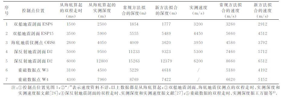
(2) 根据研究区内深反射地震、双船折射地震、海底地震仪地震测线、重磁等资料,在各个构造单元选择控制点读取深部地层的时间-深度数据;
(3) 将选取的控制点时深数据与选取的井VSP数据拟合二次多项式的时深关系式,进而得到时速曲线;
(4) 用深反射地震和双船折射地震等得到的深部速度及基底和莫霍面的理论速度,验证拟合时深尺的合理性.如果合理,应用时深尺进行时深转换;如不合理,则转至步骤(2),继续选取控制点,直至计算的速度合理.
3.2 浅水区深部基底地层的地震时深转换在珠江口盆地浅水区各个构造单元中选取了钻遇基底或完钻深度较大的13 口井,用其VSP 数据拟合时深尺.海水会影响时深尺拟合的效果,因此需去掉海水影响,然后拟合时深尺,最后再加上水深,拟合公式如下:
|
(1) |
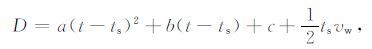
式中D为某点深度;t为某点双程走时;ts 为某点海底双程走时;vw 为海水的速度;a,b,c为拟合因子.以上方法对水深变化能很好的消除.
公式(1)两端对t进行求导,得到时-速关系式为:
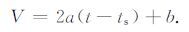
|
(2) |
在岩性和地质年代相同的条件下,地震波的速度随岩石埋藏深度的增大而增大.通常认为,南海北部新生界底界面Tg以上的速度一般不超过5500 m/s,上地壳在6000~6500 m/s,下地壳速度在6500~7600m/s,莫霍面上的速度不会超过8000m/s[27~30].所以可用拟合的时速关系是否符合理论的速度变化来判断拟合的时深公式的合理性.若拟合的速度变化超出上述理论范围,则认为该公式在超出理论值的深度段上不能应用.
按照传统方法,应用选取的13 口井的VSP 数据进行拟合,得到如下二次多项式形式的时深公式(拟合曲线见图 2):
|
(3) |

|
图 2 浅水区常规方法拟合的时深关系(D-t)和时速关系(V-t)曲线 VSP为垂直地震剖面. Fig. 2 Curves fitted to the time-depth and time-velocity data by conventional method in shallow-water area |
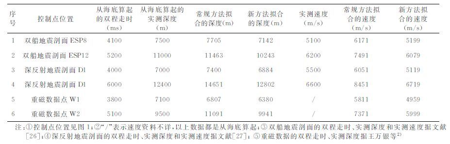
公式(3)应用于深部地层的时深转换时,发现拟合的深度和速度产生较大的误差(见表 1第5、8列和表 2).
|
|
表 1 浅水区深部地层控制点拟合的时深、时速数据 Table 1 Reference to fitted depth and velocity in deep-seated strata of shallow-water area |
|
|
表 2 浅水区凹陷中心Tg和莫霍面的时速拟合数据 Table 2 Fitted velocity of Tg and Moho at the center of sag of shallow-water area |
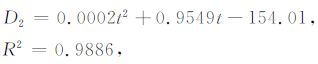
应用本文提出的方法,根据研究区内深反射地震、双船折射地震和重磁数据等资料选取6 个控制点(见表 1),读取深部地层的时间-深度数据(表 1第3、4列),与13口井的VSP 数据拟合了新的二次多项式形式的时深公式(拟合曲线见图 3):
|
(4) |

|
图 3 浅水区校正拟合的时深关系(D-t)和 时速关系(V-t)曲线 VSP为垂直地震剖面;DSRP为深反射地震剖面;ESP为 双船折射地震剖面;重磁数据据王万银重磁解释资料2) Fig. 3 Corrected curves fitted to the time-depth and time-velocity data in shallow-water area |
2)王万银,潘玉,陈石等.中国近海及邻区重、磁资料连片处理及解释成果报告和图册.中国海洋石油研究中心勘探研究院,2004
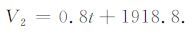
其中D2 代表用二次多项式拟合的的深度(从海底算起),单位为m;t代表双程反射时间(从海底算起),单位为ms.然后利用公式(4)进行时深转换后加上水深即为最终结果.其时速关系式为线性方程:
|
(5) |
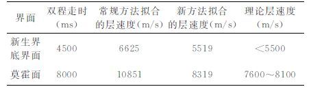
通过时深公式的计算,本文提出的方法在浅部地层拟合深度的最大误差小于200 m,多数不超过100m;从表 1 可以看出,超出钻井深度控制范围外,深部控制点用常规方法拟合的层速度普遍都偏大;表 2 中凹陷中心新生界底界面出现在海底约4500ms,常规方法拟合的层速度达到6625m/s,莫霍面的速度更是离谱的达到10851 m/s,显然其时深关系式不适用于深部地层转换.而本文提出方法拟合的时深、时速曲线向深部梯度变缓(图 3),控制点拟合的层速度偏差不大,在Tg和莫霍面的速度接近合理的速度范围,适合做深部地层的时深转换.
实际计算和理论分析表明,深部地层下延段校正法拟合的时深关系式在浅水区既适用于浅部地层又适用深部地层的时深转换.
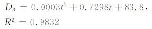
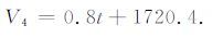
3.3 深水区深部基底地层的地震时深转换珠江口盆地的深水区水深在300~4000 m,钻井较少,选取钻遇基底或完钻深度较大的5口井.根据这5口探井VSP数据,按照常规方法拟合的二次多项式时深关系式:
|
(6) |
公式(6)应用于深部地层的时深转换时,从图 4中常规方法的拟合曲线来看,其时深曲线在钻井深度控制范围外急剧下滑,深部外延的速度偏大(见表 3第5、8列和表 4),在大面积无井控制区深度和速度误差大.

|
图 4 深水区常规方法拟合的时深关系(D-t)和时速关系(V-t)曲线 Fig. 4 Curves fitted to the time-depth and time-velocity data by conventional method in deep-water area |
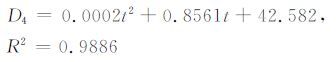
应用本文提出的方法,根据研究区内双船折射地震、海底地震仪测点、深反射地震和重磁数据等资料选取7个控制点(见表 3),读取深部地层的时间-深度数据(表 3第3、4列),与5口井的VSP数据拟合了新的二次多项式形式的时深公式(曲线见图 5):
|
(7) |
|
|
表 3 深水区深部地层控制点拟合时深、时速数据 Table 3 Reference to fitted depth and velocity in deep-seated strata of deep-water area |

|
图 5 深水区校正拟合的时深关系(D-t)和 时速关系(V-t)曲线 Fig. 5 Corrected curves fitted to the time-depth and time-velocity data in deep-water area |
其时速关系式为线性方程:
|
(8) |
由表 3和图 5可以看出,由于浅部VSP 数据已控制时深曲线的走向,浅部控制点ESP6 对时深转换数据约束不大,而深部控制点拟合时则使曲线向下弯曲,在深部下延段时深转换中发挥主要作用.
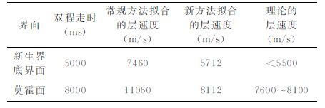
通过时深公式的计算,本文提出的方法在浅部地层拟合深度的误差小于200m,拟合效果好;从表 3可以看出,超出钻井深度控制范围外,在深部控制点常规方法拟合的层速度普遍都偏大.表 4 中在凹陷中心新生界底界面出现在海底约5000 ms,常规方法拟合的层速度达到7460m/s,莫霍面速度达到了11060m/s,显然其时深关系式不适用于深部地层转换.而本文提出方法拟合的时深、时速曲线向深部梯度变缓,控制点拟合的层速度偏差不大(图 5),在Tg和莫霍面的速度接近合理的速度范围,适合做深部地层的时深转换.
|
|
表 4 深水区白云凹陷中心Tg和莫霍面的时速拟合数据 Table 4 Fitted velocity of Tg and Moho at the center of Baiyun sag of deep-water area |
实例计算和理论分析表明,深部地层下延段校正法拟合的时深关系式在深水区既适用于浅部又适用深部地层的时深转换.
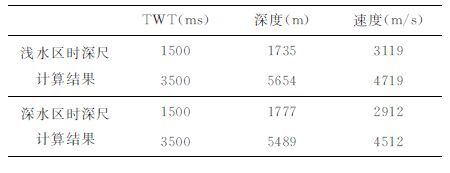
3.4 用基底时深转换关系编制珠江口盆地基底等深图以珠江口盆地的二维地震测线为基础资料,选取80 条过井地震剖面(位置见图 1,覆盖了主要的构造单元).对新生代基底底界面进行地震剖面解释,得到珠江口盆地基底的等t0 图.根据拟合的时深尺分别对浅水区和深水区的等t0 图进行时深转换,得到基底的深度数据,用克里金插值法[31, 32]进行网格化[33~35],完成珠江口盆地基底顶界面等深度图(见图 1).
在浅水区和深水区交界处应用不同的时深尺,会得到不同的结果(见表 5).因此应用克里金法进行插值,以减少其误差.
|
|
表 5 深水区和浅水区的拟合公式在分界处Tg深度和速度对比 Table 5 Fitted depths and velocity of Tg between shallow-water area and deep-water area |
实例计算和理论分析表明,常规时深转换方法不适用于深部的时深转换.而本文提出的方法,通过添加深部地层控制点而拟合计算的结果,更接近于深部地层基准面的理论速度与选取的控制点的实际速度和深度,有利于更准确地确定盆地和构造的真实形态.
| [1] | 杨文采, 杨午阳, 程振炎. 中国大陆科学钻探孔区的地震波速模型. 地球物理学报 , 2006, 49(2): 477–489. Yang W C, Yang W Y, Cheng Z Y. Seismic velocity model of the Chinese continental scientific drilling site. Chinese J. Geophys. (in Chinese) , 2006, 49(2): 477-489. |
| [2] | 张华军, 肖富森, 刘定锦, 等. 地质构造约束层速度模型在时深转换中的应用. 石油物探 , 2003, 42(4): 521–525. Zhang H J, Xiao F S, Liu D J, et al. Geologic structure constrained interval velocity model and its application in time-depth conversion. Geophysical Prospecting for Petroleum (in Chinese) , 2003, 42(4): 521-525. |
| [3] | 黄兆辉, 底青云, 唐必锐, 等. 速度控制点法在川东高陡构造时深转换中的应用. 地球物理学进展 , 2008, 23(3): 717–721. Huang Z H, Di Q Y, Tang B R, et al. The application of the modeling method of velocity-controlling points to time-depth conversion in east Sichuan. Progress in Geophysics (in Chinese) , 2008, 23(3): 717-721. |
| [4] | Al-Chalabi M. Time-depth relationships for multilayer depth conversion. Geophysical Prospecting , 1997, 45(4): 715-720. DOI:10.1046/j.1365-2478.1997.520293.x |
| [5] | 熊绍柏, 刘宏兵, 王有学, 等. 华南上地壳速度分布与基底、盖层构造研究. 地球物理学报 , 2002, 45(6): 784–791. Xiong S B, Liu H B, Wang Y X, et al. A study on velocity distribution in upper crust and tectonics of basement and cover in South China. Chinese J. Geophys. (in Chinese) , 2002, 45(6): 784-791. |
| [6] | 陈洁. 北黄海前新生代残留盆地勘探潜力分析. 地球物理学进展 , 2005, 20(3): 757–760. Chen J. Potential analysis of exploration for Pre-Cenozoic marine residual basins in northern Yellow Sea. Progress in Geophysics (in Chinese) , 2005, 20(3): 757-760. |
| [7] | 刘展, 赵文举, 吴时国, 等. 冲绳海槽南部基底构造特征. 地球物理学进展 , 2006, 21(3): 814–824. Liu Z, Zhao W J, Wu S G, et al. The basement tectonics in south of the Okinawa trough. Progress in Geophysics (in Chinese) , 2006, 21(3): 814-824. |
| [8] | 刘光鼎, 陈洁. 中国前新生代残留盆地油气勘探难点分析及对策. 地球物理学进展 , 2005, 20(2): 273–275. Liu G D, Chen J. Analysis of difficulties in gas-petroleum prospecting in Chinese Pre-Cenozoic relic basin and the corresponding solutions. Progress in Geophysics (in Chinese) , 2005, 20(2): 273-275. |
| [9] | 王家林, 张新兵, 吴健生, 等. 珠江口盆地基底结构的综合地球物理研究. 热带海洋学报 , 2002, 21(2): 13–22. Wang J L, Zhang X B, Wu J S, et al. Integrated geophysical researches on base texture of Zhujiang River mouth basin. Journal of Tropical Oceanography (in Chinese) , 2002, 21(2): 13-22. |
| [10] | 郝天珧, 黄松, 徐亚, 等. 南海东北部及邻区深部结构的综合地球物理研究. 地球物理学报 , 2008, 51(6): 1785–1796. Hao T Y, Huang S, Xu Y, et al. Comprehensive geophysical research on the deep structure of Northeastern South China Sea. Chinese J. Geophys. (in Chinese) , 2008, 51(6): 1785-1796. |
| [11] | 郝天珧, 徐亚, 周立宏, 等. 前新生代残留盆地宏观分布的综合地球物理研究——以大港地区为例. 地球物理学报 , 2008, 51(2): 491–502. Hao T Y, Xu Y, Zhou L H, et al. Integrated geophysical research on macroscopic distribution of Pre-Cenozoic residual basins —A case in Dagang area. Chinese J. Geophys. (in Chinese) , 2008, 51(2): 491-502. |
| [12] | 中国科学院南海海洋研究所. 南海地质构造与陆缘扩张. 北京: 科学出版社, 1988 . South China Sea Institute of Oceanology, CAS. Geological Tectonics and Continental Margin Extension in the South China Sea (in Chinese). Beijing: Science Press, 1988 . |
| [13] | 陆基孟. 地震勘探原理. 北京: 中国石油大学出版社, 2006 . Lu J M. The Principle of Seismic Exploration (in Chinese). Beijing: China University of Petroleum Press, 2006 . |
| [14] | 孙家振, 李兰斌. 地震地质综合解释教程. 北京: 中国地质大学出版社, 2002 . Sun J Z, Li L B. Comprehensive Interpretation Course of Seism and Geology (in Chinese). Beijing: China University of Geosciences Press, 2002 . |
| [15] | 何敏, 朱明, 汪瑞良, 等. 白云深水崎岖海底区时深转换方法探讨. 地球物理学进展 , 2007, 22(3): 966–971. He M, Zhu M, Wang R L, et al. The discussion of time-depth conversion methods in the Baiyun deepwater rough seafloor area. Progress in Geophysics (in Chinese) , 2007, 22(3): 966-971. |
| [16] | Hornby B E, Yu J H, Sharp J A, et al. VSP: Beyond time-to-depth. The Leading Edge , 2006, 25(4): 446-452. DOI:10.1190/1.2193224 |
| [17] | 朱伟林, 张功成, 高乐. 南海北部大陆边缘盆地油气地质特征与勘探方向. 石油学报 , 2008, 29(1): 1–9. Zhu W L, Zhang G C, Gao L. Geological characteristics and exploration objectives of hydrocarbons in the northern continental margin basin of South China Sea. Acta Petrolei Sinica (in Chinese) , 2008, 29(1): 1-9. |
| [18] | 陈洁, 温宁, 李学杰. 南海油气资源潜力及勘探现状. 地球物理学进展 , 2007, 22(4): 1285–1294. Chen J, Wen N, Li X J. The status of the resource potential and petroleum exploration of The South China Sea. Progress in Geophysics (in Chinese) , 2007, 22(4): 1285-1294. |
| [19] | 刘震, 张功成, 吕睿, 等. 南海北部深水区白云凹陷渐新世晚期多物源充填特征. 现代地质 , 2010, 24(5): 900–909. Liu Z, Zhang G C, Lü R, et al. Feature of multi sediment-source filling during the late oligocene at Baiyun depression in the deep-water region, the Northern South China Sea. Geoscience (in Chinese) , 2010, 24(5): 900-909. |
| [20] | 姚伯初, 曾维军, 陈艺中, 等. 南海北部陆缘东部的地壳结构. 地球物理学报 , 1994, 37(1): 27–35. Yao B C, Zeng W J, Chen Y Z, et al. The crustal structure in the eastern part of the northern margin of the South China Sea. Chinese J. Geophys. (Acta Geophysica Sinica) (in Chinese) , 1994, 37(1): 27-35. |
| [21] | 杨少坤, 林鹤鸣, 郝沪军. 珠江口盆地东部中生界海相油气勘探前景. 石油学报 , 2002, 23(5): 28–33. Yang S K, Lin H M, Hao H J. Oil and gas exploration prospect of Mesozoic in the eastern part of Pearl River Mouth basin. Acta Petrolei Sinica (in Chinese) , 2002, 23(5): 28-33. |
| [22] | 张功成, 米立军, 陶维祥, 等. 深水区—南海北部大陆边缘盆地油气勘探新领域. 石油学报 , 2007, 28(2): 15–21. Zhang G C, Mi L J, Tao W X, et al. Deepwater area—the new hydrocarbon prospecting area of northern continental margin of South China Sea. Acta Petrolei Sinica (in Chinese) , 2007, 28(2): 15-21. |
| [23] | 袁玉松, 丁玫瑰. 南海北部深水区盆地特征及其动力学背景. 海洋科学 , 2008, 32(12): 102–110. Yuan Y S, Ding M G. Characteristics and geodynamic setting of the basins in deepwater area of the Northern South China Sea Margin. Marine Sciences (in Chinese) , 2008, 32(12): 102-110. |
| [24] | 周蒂, 胡登科, 何敏, 等. 深部地层时深转换中的拟合式选择问题. 地球科学—中国地质大学学报 , 2008, 33(4): 531–537. Zhou D, Hu D K, He M, et al. The selection of fitting curve in time-depth transformation of deep-seated strata and crust. Earth Science—Journal of China University of Geosciences (in Chinese) , 2008, 33(4): 531-537. DOI:10.3799/dqkx.2008.067 |
| [25] | 王衍堂, 陈玲, 吴大明. 南海中建南盆地速度资料分析与应用. 热带海洋学报 , 2006, 25(5): 49–55. Wang Y T, Chen L, Wu D M. Velocity data analysis and its application to Zhongjiannan Basin in South China Sea. Journal of Tropical Oceanography ( in Chinese) (in Chinese) , 2006, 25(5): 49-55. |
| [26] | 姚伯初, 万玲, 曾维军, 等. 中国南海海域岩石圈三维结构及演化. 北京: 地质出版社, 2006 . Yao B C, Wan L, Zeng W J, et al. The Three-Dimensional Structure of Lithosphere and Its Evolution in the South China Sea (in Chinese). Beijing: The Geological Publishing House, 2006 . |
| [27] | 黄春菊, 周蒂, 陈长民, 等. 深反射地震剖面所揭示的白云凹陷的深部地壳结构. 科学通报 , 2005, 50(11): 1131–1138. Huang C J, Zhou D, Chen C M, et al. Deep crustal structure of Baiyun Sag, northern South China Sea revealed from deep seismic reflection profile. Chinese Science Bulletin (in Chinese) , 2005, 50(11): 1131-1138. |
| [28] | Nissen S S, Hayes D E, Buhl P, et al. Deep penetration seismic soundings across the northern margin of the South China Sea. J. Geophys. Res. , 1995, 100(B11): 22407-22433. DOI:10.1029/95JB01866 |
| [29] | Nissen S S, Hayes D E, Yao B C, et al. Gravity, heat flow, and seismic constraints on the processes of crustal extension: Northern margin of the South China Sea. J. Geophys. Res. , 1995, 100(B11): 22447-22483. DOI:10.1029/95JB01868 |
| [30] | 张中杰, 刘一峰, 张素芳, 等. 南海北部珠江口—琼东南盆地地壳速度结构与几何分层. 地球物理学报 , 2009, 52(10): 2461–2471. Zhang Z J, Liu Y F, Zhang S F, et al. Crustal P-wave velocity structure and layering beneath Zhujiangkou-Qiongdongnan basins, the northern continental margin of South China Sea. Chinese J. Geophys. (in Chinese) , 2009, 52(10): 2461-2471. |
| [31] | 邵才瑞, 印兴耀, 李洪奇, 等. 储层属性的遗传神经克里金插值方法及其应用. 中国石油大学学报(自然科学版) , 2007, 31(5): 35–40. Shao C R, Yin X Y, Li H Q, et al. An integrated genetic-neural-Kriging interpolation method for reservoir property and its application. Journal of China University of Petroleum (Edition of Natural Science) (in Chinese) , 2007, 31(5): 35-40. |
| [32] | 李信富, 李小凡. 分形插值地震数据重建方法研究. 地球物理学报 , 2008, 51(4): 1196–1201. Li X F, Li X F. Seismic data reconstruction with fractal interpolation. Chinese J. Geophys. (in Chinese) , 2008, 51(4): 1196-1201. |
| [33] | 赵长煜, 宋海斌, 钱荣毅, 等. 叠合盆地构造热演化模拟方法研究—以江汉盆地为例. 地球物理学报 , 2010, 53(1): 128–137. Zhao C Y, Song H B, Qian R Y, et al. Research on tectono-thermal evolution modeling method for superimposed basin with the Jianghan Basin as an example. Chinese J. Geophys. (in Chinese) , 2010, 53(1): 128-137. |
| [34] | 陈林, 宋海斌, 许鹤华, 等. 张裂大陆边缘形成演化的数值模拟. 地球物理学报 , 2009, 52(11): 2781–2787. Chen L, Song H B, Xu H H, et al. The numerical modeling of the formation and evolution of rifted continental margin. Chinese J. Geophys. (in Chinese) , 2009, 52(11): 2781-2787. |
| [35] | 张健, 宋海斌, 李家彪. 南海西南海盆构造演化的热模拟研究. 地球物理学报 , 2005, 48(6): 1357–1365. Zhang J, Song H B, Li J B. Thermal modeling of the tectonic evolution of the southwest subbasin in the South China Sea. Chinese J. Geophys. (in Chinese) , 2005, 48(6): 1357-1365. |