2. 中国科学院研究生院, 北京 100049;
3. 中国科学院地质与地球物理研究所, 北京 100029
2. Graduate University of Chinese Academy of Sciences, Beijing 100049, China;
3. Institute of Geology and Geophysics, Chinese Academy of Sciences, Beijing 100029, China
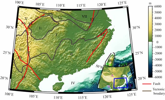
华南地区位于欧亚板块、印度板块和菲律宾海板块的交接地带,西倚青藏高原,北以秦岭-大别造山带为界,东南濒临西太平洋,呈现出一幅内陆到陆缘及沟、弧、盆系列的地貌景观.华南地区主要由扬子地块和华夏地块组成.该大陆地块经历过多期次的“拼合-裂解-再拼合"[1],具有复杂地质构造特征(具体的构造单元见图 1).其中,扬子地块西北部的四川盆地位于龙门山东侧,是我国西南地区惟一的大型中生代前陆盆地[2](油气资源丰富),与青藏高原物质东流相互作用强烈[3].扬子地块西缘的川滇地区广泛发育南北向断裂构造,地震、火山、温泉等活动活跃[4].扬子地块北侧为秦岭大别造山带和华北地块,西北侧为松潘-甘孜褶皱带.华夏地块东南缘、南缘为弧陆碰撞大陆裂解理想研究场所的台湾造山带和南海北部大陆边缘.近90 年来,我国科学家对华南地区的地质构造进行了大量的研究,取得了一系列有价值的研究成果,包括20 世纪70 年代以来,在华南地区开展的许多深部地球物理探测工作,涉及深地震测深、重力、深地震反射和宽频带地震探测等.基于重力数据获得的上地壳深度,揭示了华南地区重力异常特征与断裂带的展布特征[5];基于深地震测深资料与面波层析成像结果得到的东亚及其邻区的莫霍面深度也涉及到该研究区[6-8];基于深地震测深、深地震反射和宽频带地震信息,得到了含华南地区在内的中国大陆地区莫霍面深度图像[9-14].然而,前人的研究成果主要是基于单条剖面,对于华南地区地壳结构的整体性认识还有待加强.由于人工源地震无论是在横向上还是纵向上都有较高的分辨率,而华南地区大量的深地震测深工作为研究地壳结构提供了良好的数据基础,为此,我们收集研究区内人工源地震剖面研究成果,构建华南地区三维地壳结构模型,对莫霍面深度、Pn 波速度以及典型构造单元地壳属性、扬子地块与华北地块碰撞等地质过程、太平洋板块的俯冲方向进行了探讨.
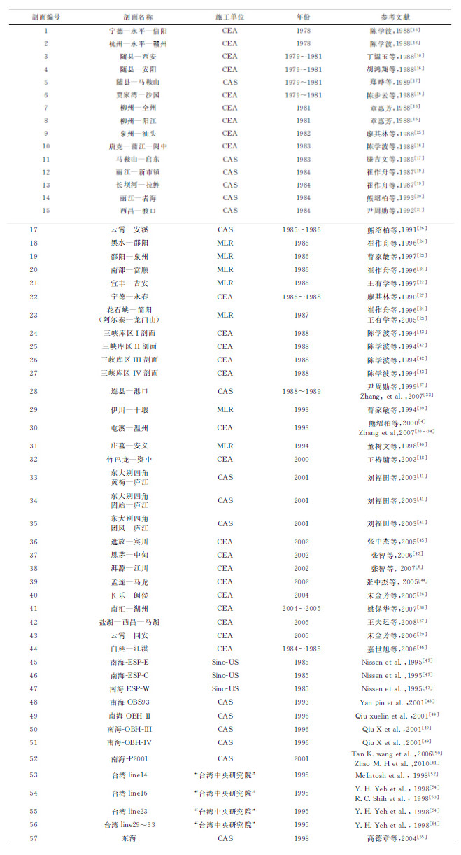
2 研究资料概述与三维地壳模型插值方法深地震测深又叫宽角反射/折射地震探测,是利用地震波传播过程中的运动学和动力学特性来约束重建地壳速度结构模型.自1958年柴达木深地震剖面探测以来[15],我国的深地震测深剖面已达60000多公里[10],与华南地区相关的深地震测深剖面总长超过20000km.华南地区的深地震测深工作起于矿山爆破.1978年,国家地震局利用江西省永平铜矿爆破(炸药当量达到了千吨级)布设了两条近于直交的剖面探测[16](“宁德-永平-信阳"西北向剖面长910km, “杭州-永平-赣州"东北向剖面长730km).1979-1981年,国家地震局和中国科学院又进行了湖北随县矿山爆破观测(西北向长400km 的“随县-西安"剖面,北向长450km 的“随县-安阳"剖面,东向长500余km 的“随县-马鞍山"剖面,西南向长417km 的“贾家湾-沙园"剖面)[16,17].1981年,中国地震局利用广西柳州太阳村水泥厂的爆破,布设了北东向222km 的“柳州-全州"剖面和北西向290km 的“柳州-阳江"剖面[16].上述的几条剖面,由于爆破点只有一炮,无法构成相遇、追逐、多重等相对完整的观测系统,因此其解释方法和结果略显粗糙[11].后期的工作都采用了比较完备的观测系统.中国地震局于1983 年实施了“唐克-蒲江-阆中"的三角剖面[16],2000年实施了560km 的“竹巴龙-资中"剖面[18].为了深入了解川滇地区的深部地质结构,中国科学院地球物理研究所于1984年进行了“丽江-新市镇",“长坝河-拉",“丽江-者海",“西昌-渡口"四条剖面的深部探测工作[19-21].随着地学大断面计划在全球的广泛进行,为了得到“阿尔泰-台湾"地学大断面的深部结构,80年代中期,中国地质科学院进行了“阿尔泰-龙门山"、“黑水-邵阳"和“邵阳-泉州"剖面的探测工作[22,23],同时在四川盆地布设了“南部-富顺"[24],在江西布设了“宜丰-吉安"剖面[22].
东南地区的福州盆地、漳州盆地断裂构造较多,而且有丰富的地热资源,中国地震局和中国科学院地球物理研究所在该区域都进行了较深入的研究.例如,1982年的“泉州-汕头"剖面[25],80年代中期的“云霄-安溪"剖面[26]、“宁德- 永春"剖面[27],2004年完成的我国第一条高分辨率地震折射、宽角反射/折射和深地震反射联合剖面-“长乐-闽侯"剖面[28],2005 年完成的160km“云霄-同安"剖面[29].对东部沿海的深部结构研究还包括中国科学院地球物理所完成的“马鞍山-启东"剖面[17]、“屯溪-温州"剖面[4,30-34],中国地震局完成的“符离集-奉贤"剖面[35]、“南汇-湖州"剖面[36].另外中国科学院地球物理所在广东地区进行了“连县-港口"剖面的探测工作[37].
|
图 1 华南地区的构造单元划分 A:欧亚板块;B:印度板块;C:菲律宾海板块;Ⅰ:扬子地块;Ⅱ:华夏地块;Ⅲ:台湾造山带;Ⅳ:南海盆地北部;Ⅴ:松潘-甘孜褶皱带东部;Ⅵ:秦岭大别造山带;Ⅶ:华北地块;I1:四川盆地;I2:川滇地区;F1:政和-大浦断裂带;F2:江山-绍兴断裂带;F3:郯庐断裂带;F4:龙门山断裂带;F5:红河断裂带;F6:鲜水河断裂带;F7:安宁河-小江断裂带;F8:奠边府断裂带. Fig. 1 The tectonicunits in South China A:Asian plate; B:Indian plate; C:Philippine sea plate; Ⅰ:Yangtze block; Ⅱ:Cathaysiablock; Ⅲ:Taiwan orogen; Ⅳ:South China Sea basin; Ⅴ:East of Songpan-Ganzifold; Ⅵ:Qinlin-Dabie orogen; Ⅶ:NorthChinablock; Ⅰ1:SichuanBasin; Ⅰ2:Chuandian area; F1:Zhenghe-Dapu fault belt; F2:Jiangshan-Shaoxing fault belt; F3:Tanlu fault belt; F4:Longmenshan fault belt; F5:Honghe fault belt; F6:Xianshuihe fault belt; F7:An′ninghe-Xiaojiang fault belt; F8:Dianbianfu fault belt. |
|
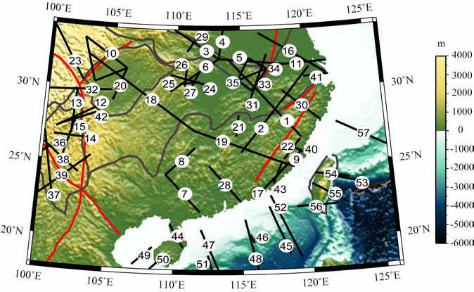
图 2 华南地区深地震测深剖面位置,构造单元如图 1,序号见表 1 Fig. 2 The DSS profiles in SouthChina, the tectonicunits is the same asFig.1serial number refer toTable 1 |
秦岭-大别造山带被认为是扬子-华北陆块之间的陆陆造山带,存在大陆俯冲与超高压变质作用[38].为了得到该区域地壳深部结构,中国地质科学院,中国地震局和中国科学院地球物理所先后完成了“伊川-十堰",“庄墓-安义"两条剖面,“东大别四角"三条剖面的探测工作[39-41].
三峡大坝的坝基安全问题与深部结构存在必然的联系.1988 年,中国地震局在三峡库区进行了4条剖面的深地震测深工作[42],为三峡大坝位置的最终确定,以及坝基安全性提供了保障.
为了研究云南地区强烈的地震、火山等的深部构造成因,印度板块与欧亚板块持续碰撞的地壳变形机制,四条宽角反射剖面2002年在中美合作项目下展开,包括“遮放-宾川"剖面,“思茅-中甸"剖面,“洱源-江川"剖面,“孟连-马龙"剖面[6,43-45].
“白延-江洪"剖面跨越了琼州海峡[46].1985年中美合作在南海北部完成了3条剖面:ESP-W,ESP-C,ESP-E[47].20世纪90年代以来,为了探测南海的石油和天然气水合物等资源,中国科学院南海海洋研究所通过国际合作在南海进行大量的深地震测深工作:OBS93,OBH-Ⅱ,OBH-Ⅲ,OBH-Ⅳ,P2001[48-51].1995年,台湾中央研究院在台湾周边地区布设了四条剖面:line14,line16,line23,line29-33[52-54].海上的剖面还包括在东海进行的重磁地震综合探测剖面[55].
表 1总结了在华南地区进行的57条深地震测深剖面,尽量参考最新的和比较有权威性的文献.图2给出了华南地区深地震测深剖面的位置.为便于对比分析,对参考文献中的图件数字化后,用统一的色标进行显示,图 3显示了43条经过二维解释的剖面(有的剖面没有得到二维的速度结果),纵向上的单位为Depth/km, 横向上是剖面长度,单位km.可以看到,低速层广泛存在,厚度在10km 左右;在深大断裂上,莫霍面有明显错断;东西向剖面上莫霍面埋深明显西深东浅.
|
|
表 1 华南地区深地震测深剖面信息(CAS:中国科学院;CEA:中国地震局;MLR:中国地质科学院) Table 1 The information of DSS profiles in South China (CAS : Chinese Academy of Sciences ; CEA: The China Earthquake Administration; MLR: The Mlinistry of Land and Resources of China) |
克里金插值也称空间局部估计或空间局部插值,是在变异函数理论及结构分析基础上,在有限区域通过散点值无偏、最优估计得到某一区域值分布的方法[56].它不仅考虑了预备估计点的相对位置而且还考虑了各观测点之间的相对位置关系,能够计算出每个估计值的误差大小(估计值之差),从而能知道估计值的可靠性程度.

|
图 3 华南地区的二维速度剖面,(a, b)为大陆部分;(c)为海洋部分 Fig. 3 2-Dvelocity profiles in South China, (a, b)is about land, and (c)is about ocean |
在上述二维剖面速度信息基础上,采用克里金插值技术构建了华南地区地壳三维速度结构模型.鉴于地壳具有成层性,由于界面的存在,直接采用克里金插值会影响速度的地层分布,于是采用了分层的三维克里金插值,即先在界面控制下插值,最后再根据界面拼接为三维体.三维速度结构和三维误差分布如图 4所示.由图可知:(1)地壳浅部5km 深度处,盆地内地震波速度较低(5.5km/s),造山带内地震波速度较高(6.0-6.2km/s),海洋与陆地的速度有明显的突变;(2)莫霍界面在三维速度图上能够得到较清晰的显示;(3)川滇地区的速度在横向上很不均匀,成层性较差,可能是该地区强烈构造活动的体现.由三维误差分布图像可见,剖面控制区域地震波速度误差范围在0.2km/s左右.

|
图 4 三维速度结构和误差结构.黑线为构造线,红线为断裂带,紫线为剖面位置 (a)速度的深向切片;(b)速度的经向切片;(c)速度的纬向切片;(d)误差的深向切片;(e)误差的经向切片;(f)误差的纬向切片. Fig. 4 3-Dvelocity and error structure.Black line:tectonic boundary; Red line: faults; Violet line:DSS profiles (a)The velocity in depth slice; (b)The velocity in longitude slice; (c)The velocity in latitude slice; (d)The error in depth slice; (e)The error in long itude slice; (f)The error in latitude slice. |
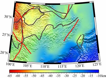
华南地区的莫霍面深度图(图 5)显示:(1)莫霍面与地形起伏具有明显的镜像相关性,与Zhang等所得到的结果类似[13].从西到东,地壳厚度由50多km 减薄到20km; (2)华南地区的大陆部分平均地壳厚度为37km 左右,其中扬子地块的莫霍面深度为40km, 华夏地块的莫霍面深度为32km 左右.南海盆地北部平均深度为23-24km[57-60],具有典型伸展区的地壳厚度.台湾造山带的莫霍面深度达到了40-45km, 具有较典型的造山带地壳厚度;四川盆地地壳厚度为40km 左右,比攀西地区的莫霍面深度浅10km 以上[61].
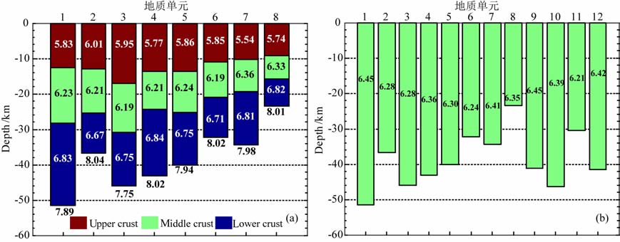
4.2 地壳性质图 1中给出了各个构造单元边界,根据各个剖面所给出的上中下地壳厚度信息可以分析出各个单元上中下地壳的平均厚度、平均速度.图 6显示了整个地壳、上中下地壳的速度-厚度特征.可能由于某些学者在解释上地壳剖面的时候没有对地壳浅部进行较详细的讨论,因此在计算的时候统一取大于5km/s的速度,这可能导致上地壳的平均速度在计算过程中会有较大的误差.川滇地区上地壳厚度最大达到17km, 其他地区12km 左右.华南地区大陆部分的地壳平均速度为6.31km/s, 比全球平均地壳速度6.45km/s[62]要小,处于全球造山带与伸展区平均速度之间,表示同时有造山带和伸展区的存在.扬子地块地壳平均速度为6.30km/s, 其中上地壳平均速度为5.86km/s, 中地壳平均速度为6.24km/s, 下地壳平均速度为6.75km/s; 华夏地块的地壳平均速度为6.24km/s, 其中上地壳平均速度为5.85km/s, 中地壳平均速度为6.19km/s, 下地壳平均速度为6.71km/s.扬子地块地壳平均速度在上中下地壳均高于华夏地块.
|
图 6 不同单元的平均速度(km/s)-平均厚度(a)上中下地壳平均速度-平均厚度图;(b)地壳平均速度-平均厚度图. 地质单元:1松潘-甘孜褶皱带东部;2秦岭大别造山带;3川滇地区;4四川盆地;5扬子地块;6华夏地块;7台湾造山带;8南海盆地北部;9全球平均;10全球造山带;11全球伸展区;12全球地台区. Fig. 6 Average velocity(km/s)-thickness in different units(a)Average velocity-thickness in upper-middle and lower crust; (b)Average velocity-thickness in crust. Tectonic units:1 East of Songpan-Garzéfold; 2 Qinling-Dabieorogen; 3 Chuandian area; 4 Sichuan basin; 5 Yangtze block; 6 Cathaysia block; 7 Taiwan orogen; 8 SouthChina Sea basin; 9 Average of global area; 10 Average of orogens; 11 Average of extended crust; 12 Average of plat forms. |
台湾造山带和南海盆地北部的地壳平均速度较大,可能正是对陆海地壳差异的反映;除了台湾造山带和南海盆地,华南地区地壳的平均速度在四川盆地有最大值6.36km/s, 其他区域在6.2-6.3km/s左右,下地壳速度值达到了最大的6.84km/s, 这应该与四川盆地是典型的克拉通型盆地相一致[51].从地壳的平均厚度、平均速度以及Pn 波速度对比全球模型,推测台湾造山带具有典型大陆弧的特征,四川盆地具有较典型的地台区特征,华夏地块具有全球伸展区的特征.
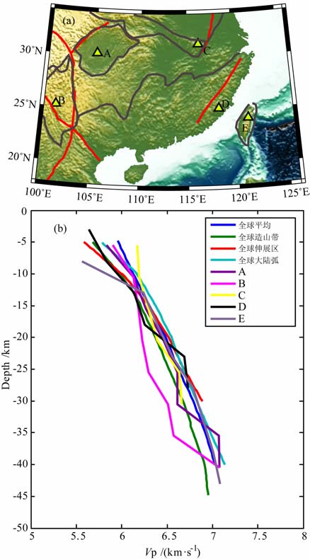
为了更清晰地对比各个地区的速度与全球模型的差异,图 7给出了华南地区五个不同点的速度-深度与全球的对比结果.可以看到四川盆地的A 点与全球的速度-深度相比具有较大的相似性,下地壳速度较大,变化较复杂;川滇地区的B 点中下地壳速度明显低于全球平均速度,比全球造山带也要低,可能说明该处的地壳受到地幔热物质作用较大,中下地壳相对偏酸性[45];大别造山带的C 点与全球的造山带平均速度类似;东南沿海的D 点速度结构较复杂,在12km 左右有低速层存在;台湾造山带的E点上部速度与造山带接近,而中下部与全球大陆弧接近.
|
图 7 华南地区不同点的速度-深度结构与全球的对比 (a)点的位置;(b)速度-深度关系. Fig. 7 Comparis on between the velocity-depth structure of different points in SouthChina with global area (a)The position of points; (b)Velocity-depth relationship. |
Pn波的传播路径位于莫霍面下方的上地幔顶部,其波速变化对于确定壳幔边界附近的介质结构、建立地壳和上地幔的构造关系有着十分重要的意义.一般认为在构造活动比较弱的地区,例如古老盆地、地台等都呈现高速;而在新构造活动比较强烈的地区,例如活动的造山带、伸展盆地、火山区等则呈现低速[63],另外Pn速度大小与地壳内部物质强度和流动性相关,可能是上地幔顶部温度的表征.
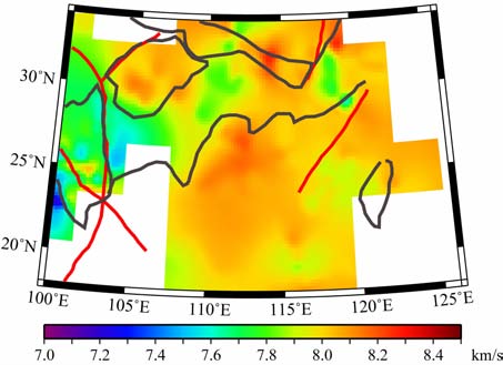
利用各条剖面的Pn波速度进行插值得到了整体的Pn速度值(图 8).华南地区大陆部分Pn波速度的平均值为7.97 km/s, 比全球的平均值8.09km/s[62]稍低,说明从整体来说构造活动性是比较强烈的.龙门山东西两侧有明显的差异,东部的四川盆地速度偏高达到8.1-8.2km/s, 西部的松潘-甘孜褶皱带东部速度偏低为7.8-7.9km/s, 这主要是因为该区域位于青藏高原东部,属于造山带,而四川盆地是坚硬的地台区,因此速度的差异反映了活动造山带和稳定地块不同的岩石层地幔特性[63];而胥颐等根据层析成像得到的Pn 波速度认为松潘-甘孜造山带的岩石圈地幔强度较弱,推测青藏高原的韧性流动不仅局限于地壳中下层,而是深入到上地幔顶部[64].川滇地区呈现明显的低速,与该区域的地热分布和深部岩浆活动相一致[65],异常的低速可能由于存在地幔柱的上涌;三峡库区的Pn 波低速被认为是从地台区向造山带的过渡所致[42];大别山区东侧的低速被认为是复杂岩浆房构造的结果[4];台湾造山带显示出的低速与岛弧俯冲带强烈的地震、火山以及岩浆活动有关;福建东南部的低速应该是与该地区的深部热物质作用相关,为地热田的深部热源;南海北部的低速可能与形成天然气水合物的深部热作用存在联系.在扬子地块和华夏地块的大范围区域都是速度较高,反映了稳定地区的岩石层地幔特点.而在海南地区没有发现低速层,可能是由于海南地幔柱上升的高度没有达到莫霍面,也可能是由于资料的不足.
|
图 8 华南地区的Pn速度分布,构造单元如图 1 Fig. 8 Pn velocity distribution in South China, the tectonic units is the same asFig.1 |
松潘-甘孜褶皱带东部Pn 波平均速度为7.89km/s, 秦岭大别造山带平均速度为8.04km/s, 川滇地区平均速度最低为7.75km/s, 四川盆地平均速度为8.02km/s, 扬子地块平均速度为7.94km/s, 华夏地块为8.02km/s, 台湾造山带为7.98km/s, 南海盆地北部为8.01km/s.因此川滇地区和松潘-甘孜褶皱带东部构造活动性相对较强,而四川盆地和华夏地块则相对较稳定.
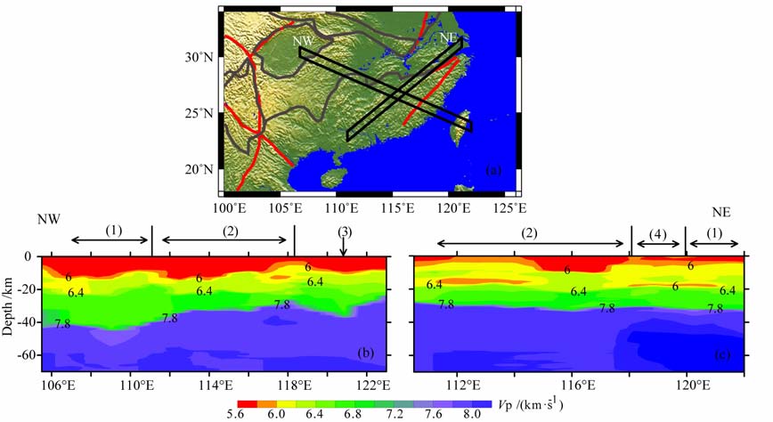
4.4 太平洋板块可能的俯冲方向华南的陆内变形以“多动力、广分布"为特征,可能既受太平洋板块俯冲的影响,又受印度-亚洲大陆碰撞的控制,推测早期的褶皱方向为NE 向(二叠纪-侏罗纪),晚期褶皱方向为NW 向(三叠纪-白垩纪)[66].但中生代以来太平洋板块向欧亚大陆俯冲的方向还存在争论.古地理的研究结果认为中侏罗纪太平洋板块正向俯冲于东亚大陆,至早白垩世初期正北斜向俯冲,早白垩世中期逐渐变成NNW 向俯冲,各个时期的俯冲速度和方向都存在差异[67].孙文斌等利用哈佛大学震源机制资料推测西太平洋板块水平向运动的主动力方向为283°[68].跨断层形变测量显示NE 向断层呈压性运动,NW 向断层呈张性运动,GPS资料显示华南地区现今最大主压应力方向为NW(NWW)-SE(SEE)向[69].Li等根据华南地区火成岩省的分布和年龄特征,提出了西太平洋板块向欧亚板块NW 向的俯冲模式,最终形成了1300km 宽的陆内造山带.本文中,我们截取了西北向和东北向的两条地壳速度走廊(图 9).莫霍面沿NW 向加深,下地壳逐渐增厚;NE 向莫霍面形态变化不大;从速度结构的变化特征来看,华南地区构造变形的主方向是NW-SE 向.西太平洋向华南地区俯冲的方向应该是NW-SE 向.
|
图 9 西北向和东北向通道的速度结构 (1)扬子地块;(2)华夏地块;(3)台湾造山带;(4)江绍断裂带. Fig. 9 The velocity structure in northwest and northeast channels (1)Yangtze block; (2)Cathaysia block; (3)Taiwan orogen; (4)Jiangshao fault belt. |
对华南地区实施的57条深地震测深P 波速度剖面数字化,利用三维克里金插值构建了三维速度结构,并对结果进行了评价,同时得到了莫霍面的深度、Pn波速度大小分布情况,对不同构造单元进行了地壳性质的讨论,对太平洋板块向欧亚板块的俯冲方向作了探讨.得到如下初步结论:
(1) 扬子地块的莫霍面深度为40km 左右,华夏地块的莫霍面深度为32km 左右.南海盆地北部平均深度为23-24km.台湾造山带的莫霍面深度达到了40-45km; 四川盆地40km 左右;东大别山的最深处达到了41km.
(2) 扬子地块地壳平均速度为6.30km/s, 其中上地壳平均速度为5.86km/s, 中地壳平均速度为6.24km/s, 下地壳平均速度为6.75km/s; 华夏地块的地壳平均速度为6.24km/s, 其中上地壳平均速度为5.85km/s, 中地壳平均速度为6.19km/s, 下地壳平均速度为6.71km/s; 扬子地块Pn波平均速度为7.94km/s, 华夏地块为8.02km/s.
(3) 扬子地块的四川盆地具有典型全球地台区特点,华夏地块具有全球伸展区的特点,而台湾造山带具有较典型全球大陆弧的特点.川滇地区和松潘-甘孜褶皱带东部构造活动性相对较强,而四川盆地和华夏地块则相对较稳定.(4)由速度结构得出的构造变形特征推测太平洋板块向欧亚板块俯冲的方向为NW-SE 向.
致谢本文在书写过程中得到中国科学院地质与地球物理研究所张中杰研究员的指导和启发,并受益于两位评审专家的宝贵意见,在此表示衷心感谢!
| [1] | 滕吉文, 王光杰, 张中杰, 等. 华南大陆S波三维速度结构与郯庐断裂带的南延. 科学通报 , 2000, 45(23): 2492–2498. Teng J W, Wang G J, Zhang Z J, et al. 3-D S-wave velocity structure of South China continent and southward extending of Tanlu fault. Chinese Science Bulletin (in Chinese) , 2000, 45(23): 2492-2498. |
| [2] | 张先, 陈秀文, 赵丽, 等. 四川盆地及其西部边缘震区基底磁性界面与地震的研究. 中国地震 , 1996, 12(4): 421–427. Zhang X, Chen X W, Zhao L, et al. Basement magnetic interface and earthquakes in seismic area of Sichuan Basin and its western margin. Earthquake Research in China (in Chinese) , 1996, 12(4): 421-427. |
| [3] | Zhang Z J, Yuan X H, Chen Y, et al. Seismic signature of the collision between the East Tibetan escape flow and the Sichuan basin. Earth and Planetary Science Letters , 2010, 292(3-4): 254-264. DOI:10.1016/j.epsl.2010.01.046 |
| [4] | 熊绍柏, 刘宏兵. 浙皖地区地壳-上地幔结构和华南与扬子块体边界. 地球物理学进展 , 2000, 15(4): 3–17. Xiong S B, Liu H B. Crust-mantle structure of Zhejiang-Anhui Region and the boundary between Yangzi Block and Huanan Block. Progress in Geophysics (in Chinese) , 2000, 15(4): 3-17. |
| [5] | Zeng H L, Zhang Q H, Li Y S, et al. Crustal structure inferred from gravity anomalies in South China. Tectonophysics , 1997, 283(1-4): 189-203. DOI:10.1016/S0040-1951(97)00153-4 |
| [6] | 张智, 徐春明, 孟补在, 等. 洱源-江川宽角地震剖面的地壳反射特征. 地球物理学报 , 2007, 50(4): 1082–1087. Zhang Z, Xu C M, Meng B Z, et al. Crustal reflectivity characters from the Eryuan-Jiangchuan wide-angle seismic profile. Chinese J. Geophys. (in Chinese) , 2007, 50(4): 1082-1087. |
| [7] | 朱介寿, 曹家敏, 蔡学林, 等. 东亚及西太平洋边缘海高分辨率面波层析成像. 地球物理学报 , 2002, 45(5): 646–664. Zhu J S, Cao J M, Cai X L, et al. High resolution surface wave tomography in East Asia and West Pacific marginal seas. Chinese J. Geophys. (in Chinese) , 2002, 45(5): 646-664. |
| [8] | 滕吉文, 曾融生, 闫雅芬, 等. 东亚大陆及周边海域Moho界面深度分布和基本构造格局. 中国科学(D辑:地球科学) , 2002, 32(2): 89–100. Teng J W, Zeng R S, Yan Y F, et al. Depth distribution of Moho and tectonic framework in eastern Asian continent and its adjacent Ocean areas. Science in China (Series D) (in Chinese) , 2002, 32(2): 89-100. |
| [9] | Li S L, Mooney W D. Crustal structure of China from deep seismic sounding profiles. Tectonophysics , 1998, 288(1-4): 105-113. DOI:10.1016/S0040-1951(97)00287-4 |
| [10] | Li S L, Mooney W D, Fan J C. Crustal structure of mainland China from deep seismic sounding data. Tectonophysics , 2006, 420(1-2): 239-252. DOI:10.1016/j.tecto.2006.01.026 |
| [11] | 熊小松, 高锐, 李秋生, 等. 深地震探测揭示的华南地区莫霍面深度. 地球学报 , 2009, 30(6): 774–786. Xiong X S, Gao R, Li Q S, et al. The Moho depth of South China revealed by seismic probing. Acta Geoscientia Sinica (in Chinese) , 2009, 30(6): 774-786. |
| [12] | 郑圻森, 朱介寿, 宣瑞卿, 等. 华南地区地壳速度结构分析. 沉积与特提斯地质 , 2003, 23(4): 9–13. Zheng Q R, Zhu J S, Xuan R Q, et al. An approach to the crustal velocities in southern China. Sedimentary Geology and Tethyan Geology (in Chinese) , 2003, 23(4): 9-13. |
| [13] | Zhang Z J, Yang L Q, Teng J W, et al. An overview of the earth crust under China. Earth-Science Reviews , 2011, 104(1-3): 143-166. DOI:10.1016/j.earscirev.2010.10.003 |
| [14] | 曾融生, 孙为国, 毛桐恩, 等. 中国大陆莫霍界面深度图. 地震学报 , 1995, 17(3): 322–327. Zeng R S, Sun W G, Mao T E, et al. Depth map of Moho of continental China. Acta Seismologica Sinica (in Chinese) , 1995, 17(3): 322-327. |
| [15] | 曾融生, 滕吉文, 阚荣举, 等. 我国西北地区地壳中的高速夹层. 地球物理学报 , 1965, 14(2): 94–106. Zeng R S, Teng J W, Gan R J, et al. The high velocity imbedded layer in the crust of Northwestern China. Chinese J. Geophys. (Acta Geophysica Sinica) (in Chinese) , 1965, 14(2): 94-106. |
| [16] | 国家地震局科技监测司. 中国大陆深部构造的研究与进展. 北京: 地质出版社, 1988 . Department of Scientific Programming and Earthquake Monitoring, China Earthquake Administration. Developments in the Research of Deep Structures of Chinese Continent (in Chinese). Beijing: Geological Press, 1988 . |
| [17] | 郑晔, 滕吉文. 随县-马鞍山地带地壳与上地幔结构及郯庐构造带南段的某些特征. 地球物理学报 , 1989, 32(6): 648–659. Zheng Y, Teng J W. The structure of the crust and upper mantle in the Suixian-Ma'anshan zone and some characteristics of the south part of the Tanlu tectonic belt. Chinese J. Geophys. (Acta Geophysica Sinica) (in Chinese) , 1989, 32(6): 648-659. |
| [18] | 王椿镛, 吴建平, 楼海, 等. 川西藏东地区的地壳P波速度结构. 中国科学(D辑:地球科学) , 2003, 33(Suppl): 181–189. Wang C Y, Wu J P, Lou H, et al. P-wave crustal velocity structure in western Sichuan and eastern Tibetan region. Science in China (Series D) (in Chinese) , 2003, 33(Suppl): 181-189. |
| [19] | 崔作舟, 卢德源, 陈纪平, 等. 攀西地区的深部地壳结构与构造. 地球物理学报 , 1987, 30(6): 566–580. Cui Z Z, Lu D Y, Chen J P, et al. The deep structural and tectonic features of the crust in Panxi area. Chinese J. Geophys. (Acta Geophysica Sinica) (in Chinese) , 1987, 30(6): 566-580. |
| [20] | 熊绍柏, 郑晔, 尹周勋, 等. 丽江-攀枝花-者海地带二维地壳结构及其构造意义. 地球物理学报 , 1993, 36(4): 434–444. Xiong S B, Zheng Y, Yin Z X, et al. The 2-D structure and it's tectonic implications of the crust in the Lijiang-Panzhihua-Zhehai Region. Chinese J. Geophys. (Acta Geophysica Sinica) (in Chinese) , 1993, 36(4): 434-444. |
| [21] | 尹周勋, 熊绍柏. 西昌-渡口-牟定地带二维地壳结构的爆炸地震研究. 地球物理学报 , 1992, 35(4): 451–458. Yin Z X, Xiong S B. Explosion seismic study for the 2-D crustal structure in Xichang-Dukou-Mudian Region. Chinese J. Geophys. (Acta Geophysica Sinica) (in Chinese) , 1992, 35(4): 451-458. |
| [22] | 袁学诚. 阿尔泰:台湾地学断面论文集. 武汉: 中国地质大学出版社, 1997 . Yuan X C. Altay: Taiwan Geoscience Transect Papers (in Chinese). Wuhan: China University of Geoscience Press, 1997 . |
| [23] | 王有学, MooneyW D, 韩果花, 等. 台湾-阿尔泰地学断面阿尔金-龙门山剖面的地壳纵波速度结构. 地球物理学报 , 2005, 48(1): 98–106. Wang Y X, Mooney W D, Han G H, et al. Crustal P-wave velocity structure from Altyn Tagh to Longmen mountains along the Taiwan-Altay geoscience transect. Chinese J. Geophys. (in Chinese) , 2005, 48(1): 98-106. |
| [24] | 崔作舟, 陈纪平, 吴苓. 阿尔泰-台湾岩石圈地学断面综合研究. 北京: 地质出版社, 1996 . Cui Z Z, Chen J P, Wu L. Memoirs of the Geoscience Transection for the Continental Lithosphere Beneath Altay-Taiwan (in Chinese). Beijing: Geological Press, 1996 . |
| [25] | 廖其林, 王振明, 王屏路, 等. 福州-泉州-汕头地区地壳结构的爆炸地震研究. 地球物理学报 , 1988, 31(3): 270–280. Liao Q L, Wang Z M, Wang P L, et al. Explosion seismic study of the crustal structure in Fuzhou-Quanzhou-Shantou Region. Chinese J. Geophys. (Acta Geophysica Sinica) (in Chinese) , 1988, 31(3): 270-280. |
| [26] | 熊绍柏, 金东敏, 孙克忠, 等. 福建漳州地热田及其邻近地区的地壳深部构造特征. 地球物理学报 , 1991, 34(1): 55–63. Xiong S B, Jin D M, Sun K Z, et al. Some characteristics of deep structure of the Zhangzhou geothermal field and it's neighbourhood in the Fujian province. Chinese J. Geophys. (Acta Geophysica Sinica) (in Chinese) , 1991, 34(1): 55-63. |
| [27] | 廖其林, 王振明, 邱陶兴, 等. 福州盆地及其周围地区地壳深部结构与构造的初步研究. 地球物理学报 , 1990, 33(2): 163–173. Liao Q L, Wang Z M, Qiu T X, et al. Preliminary research of the crustal structure in Fuzhou basin and its adjacent area. Chinese J. Geophys. (Acta Geophysica Sinica) (in Chinese) , 1990, 33(2): 163-173. |
| [28] | 朱金芳, 徐锡伟, 张先康, 等. 福州盆地及邻区地壳精细结构的深地震反射与高分辨率折射及宽角反射/折射联合探测研究. 中国科学(D辑:地球科学) , 2005, 35(8): 738–749. Zhu J F, Xu X W, Zhang X K, et al. Inspection and research on fine crust construction by using deep seismic reflection, high-resolution seismic refraction and seismic wide angle reflection/refraction. Science in China (Series D) (in Chinese) , 2005, 35(8): 738-749. |
| [29] | 朱金芳, 方盛明, 张先康, 等. 漳州盆地及其邻区地壳深部结构的探测与研究. 中国地震 , 2006, 22(4): 405–417. Zhu J F, Fang S M, Zhang X K, et al. Exploration and research of deep crustal structure in the Zhangzhou Basin and its vicinity. Earthquake Research in China (in Chinese) , 2006, 22(4): 405-417. |
| [30] | Zhang Z J, Badal J, Li Y K, et al. Crust-upper mantle seismic velocity structure across Southeastern China. Tectonophysics , 2005, 395(1-2): 137-157. DOI:10.1016/j.tecto.2004.08.008 |
| [31] | Zhang Z J, Bai Z M, Mooney Walter, et al. Crustal structure across the Three Gorges area of the Yangtze platform, central China, from seismic refraction/wide-angle reflection data. Tectonophysics , 2009, 475(3-4): 423-437. DOI:10.1016/j.tecto.2009.05.022 |
| [32] | Zhang Z J, Wang Y H. Crustal structure and contact relationship revealed from deep seismic sounding data in South China. Physics of the Earth and Planetary Interiors , 2007, 165(1-2): 114-126. DOI:10.1016/j.pepi.2007.08.005 |
| [33] | Zhang Z J, Teng J W, Badal J, et al. Construction of regional and local seismic anisotropic structures from wide-angle seismic data: crustal deformation in the southeast of China. Journal of Seismology , 2009, 13(2): 241-252. DOI:10.1007/s10950-008-9124-0 |
| [34] | Zhang Z J, Zhang X, Badal J. Composition of the crust beneath southeastern China derived from an integrated geophysical data set. Journal of Geophysical Research , 2008, 113(B4): B04417. |
| [35] | 白志明, 王椿镛. 下扬子地壳P波速度结构:符离集-奉贤地震测深剖面再解释. 科学通报 , 2006, 51(21): 2534–2541. Bai Z M, Wang C Y. Lower Yangtze crust P-wave velocity: Re-interpreted the Fuliji-Fengxian deep seismic sounding. Chinese Science Bulletin (in Chinese) , 2006, 51(21): 2534-2541. |
| [36] | 姚保华, 章振铨, 王家林, 等. 上海地区地壳精细结构的综合地球物理探测研究. 地球物理学报 , 2007, 50(2): 482–491. Yao B H, Zhang Z Q, Wang J L, et al. Prospecting and research on fine crustal structure by using multi-geophysics survey methods in Shanghai region. Chinese J. Geophys. (in Chinese) , 2007, 50(2): 482-491. |
| [37] | 尹周勋, 赖明惠, 熊绍柏, 等. 华南连县─博罗─港口地带地壳结构及速度分布的爆炸地震探测结果. 地球物理学报 , 1999, 42(3): 383–392. Yin Z X, Lai M H, Xiong S B, et al. Crustal structure and velocity distribution from deep seismic sounding along the profile of Lianxian-Boluo-Gangkou in South China. Chinese J. Geophys. (in Chinese) , 1999, 42(3): 383-392. |
| [38] | 杨文采. 东大别超高压变质带的深部构造. 中国科学(D辑) , 2003, 33(2): 183–192. Yang W C. Deep structure of eastern Dabie ultra-high pressure metamorphic belt. Science in China (Series D) (in Chinese) , 2003, 33(2): 183-192. |
| [39] | 曹家敏, 朱介寿, 吴德超. 东秦岭地区的地壳速度结构. 成都理工学院学报 , 1994, 21(1): 11–17. Cao J M, Zhu J S, Wu D C. Velocity structure of the crust in eastern Qinling Mountain. Journal of Chengdu University of Technology (in Chinese) , 1994, 21(1): 11-17. |
| [40] | 董树文, 吴宣志, 高锐, 等. 大别造山带地壳速度结构与动力学. 地球物理学报 , 1998, 41(3): 349–361. Dong S W, Wu X Z, Gao R, et al. On the crust velocity levels and dynamics of the Dabieshan Orogenic belt. Chinese J. Geophys. (in Chinese) , 1998, 41(3): 349-361. |
| [41] | 刘福田, 徐佩芬, 刘劲松, 等. 大陆深俯冲带的地壳速度结构-东大别造山带深地震宽角反射/折射研究. 地球物理学报 , 2003, 46(3): 366–372. Liu F T, Xu P F, Liu J S, et al. The crustal velocity structure of the continental deep subduction belt: study on the eastern Dabie orogen by seismic wide-angle reflection/refraction. Chinese J. Geophys. (in Chinese) , 2003, 46(3): 366-372. |
| [42] | 陈学波, 陈步云, 张四维, 等. 长江三峡工程坝区及外围深部构造特征研究. 北京: 地震出版社, 1994 . Chen X B, Chen B Y, Zhang S W, et al. The Research on Characteristics of the Deep Tectonics in Three Gorges and Nearby Area (in Chinese). Beijing: Seismological Press, 1994 . |
| [43] | 张智, 赵兵, 张晰, 等. 云南思茅-中甸地震剖面的地壳结构. 地球物理学报 , 2006, 49(5): 1377–1384. Zhang Z, Zhao B, Zhang X, et al. Crustal structure beneath the wide-angle seismic profile between Simao and Zhongdian in Yunnan. Chinese J. Geophys. (in Chinese) , 2006, 49(5): 1377-1384. |
| [44] | 张中杰, 白志明, 王椿镛, 等. 冈瓦纳型和扬子型地块地壳结构:以滇西孟连-马龙宽角反射剖面为例. 中国科学(D辑:地球科学) , 2005, 48(11): 1828–1836. Zhang Z J, Bai Z M, Wang C Y, et al. Crustal structure of Gondwana and Yangtze-typed blocks: An example by wide-angle seismic profile from Menglian to Malong in the western Yunnan. Science in China (Ser. D) (in Chinese) , 2005, 48(11): 1828-1836. DOI:10.1360/03yd0547 |
| [45] | 张中杰, 白志明, 王椿镛, 等. 三江地区地壳结构及动力学意义:云南遮放-宾川地震反射/折射剖面的启示. 中国科学(D辑:地球科学) , 2005, 48(9): 1329–1336. Zhang Z J, Bai Z M, Wang C Y, et al. The crustal structure under Sanjiang and its dynamic implications: Revealed by seismic reflection/refraction profile between Zhefang and Binchuan, Yunnan. Science in China (Ser. D) (in Chinese) , 2005, 48(9): 1329-1336. DOI:10.1360/01YD0567 |
| [46] | 嘉世旭, 李志雄, 徐朝繁, 等. 雷琼拗陷地壳结构特征. 地球物理学报 , 2006, 49(5): 1385–1394. Jia S X, Li Z X, Xu Z F, et al. Crustal structure features of the Leiqiong depression in Hainan Province. Chinese J. Geophys. (in Chinese) , 2006, 49(5): 1385-1394. |
| [47] | Nissen S S, Hayes D E, Buhl P, et al. Deep penetration seismic soundings across the northern margin of the South China Sea. Journal of Geophysical Research , 1995, 100(B11): 22407-22433. DOI:10.1029/95JB01866 |
| [48] | Yan P, Zhou D, Liu Z S. A crustal structure profile across the northern continental margin of the South China Sea. Tectonophysics , 2001, 338(1): 1-21. DOI:10.1016/S0040-1951(01)00062-2 |
| [49] | Qiu X L, Ye S Y, Wu S M, et al. Crustal structure across the Xisha trough, northwestern South China Sea. Tectonophysics , 2001, 341(1-4): 179-193. DOI:10.1016/S0040-1951(01)00222-0 |
| [50] | Wang T K, Chen M K, Lee C S, et al. Seismic imaging of the transitional crust across the northeastern margin of the South China Sea. Tectonophysics , 2006, 412(3-4): 237-254. DOI:10.1016/j.tecto.2005.10.039 |
| [51] | Zhao M H, Qiu X L, Xia S H, et al. Seismic structure in the northeastern South China Sea: S-wave velocity and Vp/Vs ratios derived from three-component OBS data. Tectonophysics , 2010, 480(1-4): 183-197. DOI:10.1016/j.tecto.2009.10.004 |
| [52] | Mcintosh K D, Nakamura Y. Crustal structure beneath the Nanao fore arc basin from TAICRUST MCS/OBS Line 14. Terr. Atmos. Ocean. Sci. , 1998, 9(3): 345-362. |
| [53] | Shih R C, Lin C H, Lai H L, et al. Preliminary crustal structures across central Taiwan from modeling of the onshore-offshore wide-angle seismic data. Terr. Atmos. Oceanic Sci. , 1998, 9: 317-328. |
| [54] | Yeh Y H, Shih R C, Lin C H, et al. Onshore/offshore wide-angle deep seismic profiling in Taiwan. Tao , 1998, 9(3): 301-316. |
| [55] | 高德章, 赵金海, 薄玉玲, 等. 东海重磁地震综合探测剖面研究. 地球物理学报 , 2004, 47(5): 853–861. Gao D Z, Zhao J H, Bo Y L, et al. A profile study of gravitative-magnetic and seismic comprehensive survey in the East China Sea. Chinese J. Geophys. (in Chinese) , 2004, 47(5): 853-861. |
| [56] | Isaaks E H, Mohan S R. An Introduction to Applied Geostatistics. New York: Oxford University Press, 1989 . |
| [57] | 张中杰, 刘一峰, 张素芳, 等. 琼东南盆地地壳伸展深度依赖性及其动力学意义. 地球物理学报 , 2010, 53(1): 57–66. Zhang Z J, Liu Y F, Zhang S F, et al. The depth-dependence of crustal extension beneath Qiongdongnan basin area and its tectonic implications. Chinese J. Geophys. (in Chinese) , 2010, 53(1): 57-66. |
| [58] | 张中杰, 刘一峰, 张素芳, 等. 南海北部珠江口-琼东南盆地地壳速度结构与几何分层. 地球物理学报 , 2009, 52(10): 2461–2471. Zhang Z J, Liu Y F, Zhang S F, et al. Crustal P-wave velocity structure and layering beneath Zhujiangkou-Qiongdongnan basins, the northern continental margin of South China Sea. Chinese J. Geophys. (in Chinese) , 2009, 52(10): 2461-2471. |
| [59] | 赵兵, 张素芳, 李守林. 琼东南盆地区的地壳密度与岩石结构. 地球物理学报 , 2011, 54(1): 98–107. Zhao B, Zhang S F, Li S L. Crustal density and composition models beneath Qiongdongnan basin. Chinese J. Geophys. (in Chinese) , 2011, 54(1): 98-107. |
| [60] | Zhang Z J, Deng Y F, Teng J W, et al. An overview of the crustal structure of the Tibetan plateau after 35 years of deep seismic soundings. Journal of Asian Earth Sciences , 2011, 40(4): 977-989. DOI:10.1016/j.jseaes.2010.03.010 |
| [61] | Christensen N I, Mooney W D. Seismic velocity structure and composition of the continental crust: A global view. J. Geophys. Res. , 1995, 100(B6): 9796-9788. |
| [62] | 汪素云, HearnT M, 许忠淮, 等. 中国大陆上地幔顶部Pn速度结构. 中国科学(D辑:地球科学) , 2001, 31(6): 449–454. Wang S Y, Hearn T M, Xu Z W, et al. Pn wave velocity structure at the uppermost mantle of china. Science in China (Series D) (in Chinese) , 2001, 31(6): 449-454. |
| [63] | 胥颐, 李志伟, 黄润秋, 等. 四川西部暨龙门山地区的Pn波速度和各向异性. 中国科学(地球科学) , 2010, 40(4): 452–457. Xu Y, Li Z W, Huang R Q, et al. Pn wave velocity and anisotropy in the west of Sichuan and Longmenshan. Science in China (Series D) (in Chinese) , 2010, 40(4): 452-457. |
| [64] | 黄金莉, 宋晓东, 汪素云. 川滇地区上地幔顶部Pn速度细结构. 中国科学(D辑) , 2003, 33(B04): 144–150. Huang J L, Song X D, Wang S Y. Pn velocity structure at the uppermost mantle of Chuandian. Science in China (Series D) (in Chinese) , 2003, 33(B04): 144-150. |
| [65] | 王清晨. 浅议华南陆块群的沉积大地构造学问题. 沉积学报 , 2009, 27(5): 811–817. Wang Q C. Preliminary discussion on sedimentary tectonics of the clustered continents of South China. Acta Sedimentologica Sinica (in Chinese) , 2009, 27(5): 811-817. |
| [66] | Maruyama S, Isozaki Y, Kimura G, et al. Paleogeographic maps of the Japanese Islands: Plate tectonic synthesis from 750 Ma to the present. Island Arc. , 1997, 6(1): 121-142. DOI:10.1111/iar.1997.6.issue-1 |
| [67] | 孙文斌, 和跃时. 西太平洋Benioff带的形态及其应力状态. 地球物理学报 , 2004, 47(3): 433–440. Sun W B, He Y S. Characteristics of the subduction zone in the western pacific and its stress state. Chinese J. Geophys. (in Chinese) , 2004, 47(3): 433-440. |
| [68] | 施顺英, 周硕愚, 帅平, 等. 中国大陆及其东南沿海现时地壳运动. 自然科学进展 , 2000, 10(3): 273–277. Shi S Y, Zhou S Y, Shuai P, et al. Present-day crustal movement in China continent and its southeast region. Progress in Natural Science (in Chinese) , 2000, 10(3): 273-277. |
| [69] | Li Z X, Li X H. Formation of the 1300-km-wide intracontinental orogen and postorogenic magmatic province in Mesozoic South China: A flat-slab subduction model. Geology , 2007, 35(2): 179-182. DOI:10.1130/G23193A.1 |
 2011, Vol. 54


